|
|
 |
|||
|
Staircase | Lodging | Camping | Maps | Coyote Buttes | Weather | Hiking | Backpack | Hwy 89 | Vacation | Pictures |
||||

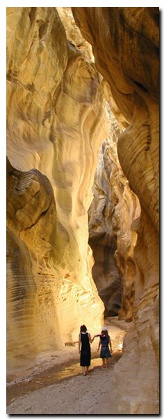
Vacation at the Grand Staircase-Escalante National Monument, UtahWinter Road Conditions Tour: Day 1 | Day 2 | Day 3 | Day 4 | Day 5 | Day 6 | Day 7 Check weather and road conditions before traveling any backway in the Grand Staircase Escalante National Monument. The rugged roads are a fun adventure, but it's primitive land and without services. Call: 1.435.644.4680 The Grand Staircase-Escalante National Monument offers some incredible slot canyon trails such as Willis Creek Slot Canyon and Lick Wash Slot Canyon. Kids enjoy playing in the cubby holes of Lick Wash.
Scenic Drive - Grand Staircase Escalante - The Grand Staircase Escalante area is surrounded by some of the most impressive primitive drives in the United States. Highway 89 is the southern boundary of the Grand Staircase. From highway 89A, on the other end of the monument, the five stair steps can be seen. The more primitive backways, such as Skutumpah Road, provide excitement for the more adventurous traveler. Visiting the Grand Staircase - The North Rim of the Grand Canyon makes up the lower step and Cedar Breaks, Red Canyon and Bryce Canyon form the top riser. Zion National Park is on the edge toward the middle. None of these surrounding parks are part of the monument but they are very much a part of the Grand Staircase geology.
Getting ready for the next day - Back to Zion National Park for more hiking. Day 6 of your vacation
Check weather information prior to hiking these trails. Flash floods are a danger in the Staircase as with any hike through a Slot Canyon.
Grand Staircase-Escalante Roads - Pristine and remote describes the roadways within the Grand Staircase Escalante National Monument. Highway 89 defines the southern border and Highway 12 accesses the northern side. In addition to Highways 12 and 89, there are 959 miles of open road in the Grand Staircase. Glendale, Utah, located on Highway 89, northeast of Zion National Park, connects the east side of Zion to Bryce Canyon via the Glendale Bench Road and the scenic backway, Skutumpah Road. To the north, Highway 12 connects Tropic and Boulder, Utah. At the southern end of the monument, roads connect Kanab, Utah and Page, Arizona. The most popular roads in the Grand Staircase are probably Skutumpah Road accessed either by the Glendale Bench Road, near the east entrance to Zion, or the Johnson Canyon Road near Kanab, both leading to Kodachrome Basin near Bryce Canyon. All interior roads except for portions of the Burr Trail and Johnson Canyon Road are unpaved and may be impassible if wet. 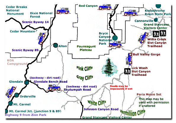
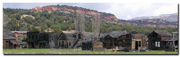
Grand Staircase-Escalante National Monument - UTAH!History of the Thunderbird |
East Zion Lodge Mileage from Stay in the heart of the parks, Mount Carmel Junction, and visit the treasures of the Southwest and Utah. Grand Staircase Skutumpah Road Cottonwood Road Hackberry Canyon Wahweap Hoodoos |
||||||||||||
|
This is my new favorite quote:
"I don't know who Mary Cisneros is, but I mean zionnational-park.com It's a better site than the NPS's anyway." Written by the authors of the book: Favorite Hikes in and around Zion National Park |
|||||||||||||
 Skutumpah Road - The Grand Staircase Escalante-National Monument entrance for this vacation itinerary is 6 miles from Mount Carmel Junction. Venture into the wilderness of the monument and hike the beautiful slot canyons,


|
Zion History |
|---|
All rights reserved © Copyright Zion National-Park dot com
Do not use text, photos or maps without permission © Zion National-Park dot com
Contact the Author Mary Cisneros with any errors