|
|
 |
|||
|
Staircase | Lodging | Camping | Maps | Coyote Buttes | Weather | Hiking | Backpack | Hwy 89 | Vacation | Pictures |
||||

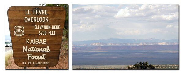
Geology of the Grand Staircase-Escalante National Monument, UtahSeveral miles out from the Utah town of Kanab, all five stair steps of the Grand Staircase-Escalante National Monument can be seen. The Staircase is huge, consisting of almost two-million acres of plateaus, mesas, buttes, slot canyons - all in a primitive setting. The photo shows the layers as seen from US Hghway 89A in Arizona, from the "Le Fevre Overlook" in Kaibab National Forest. The monument is a separate entity from other nearby parks and monuments, even though they are part of its geological makeup. For millions of years, sediments were deposited in the low lands. These sediments formed layers of sandstone, shale and mudstone. A short time ago in geological time, perhaps ten million years, the slow uplift of the Colorado Plateau began. Rock Age is from the Permian - Tertiary (275- 50 mya)
Colors and Age of the Grand Staircase - The Grand Staircase is made up of five tilted, southward, facing escarpments called stairsteps. The stairsteps rise 5500' and range from the North Rim Grand Canyon through Zion National Park to the uppermost riser, the pink cliffs of Bryce Canyon. Although there are other exposed areas of claron formation, geologists usually think of Bryce Canyon, Red Canyon and Cedar Breaks when speaking of pink cliffs. The steps of the Grand Staircase are described by their colors: chocolate, vermillion, white, gray and pink. The bottom step is made of limestone and is known as the North Rim Grand Canyon. Interestingly however, the Grand Staircase-Escalante National Monument does not include Zion, Bryce, Red Canyon, Cedar Breaks or the Grand Canyon although they are all part of its geological make-up. Oldest: Chocolate Layer - Grand Canyon - Chocolate Step - The North Rim of the Grand Canyon is the oldest and the bottom layer of the Grand Staircase. Made up of Kaibab limestone, it formed between 200 to 225 million years ago. The Chocolate layer is found between Kanab and Fredonia and the bottom layer of Kaibab limestone forms the rim of the Grand Canyon and the surface rock underlies most of the Kaibab Plateau. Vermillion Layer - Kanab - Vermillion Cliffs - These reddish or vermillion colored cliffs are about 165 to 200 million years old and are found along highway 89 near Kanab. They are made up of deposited silt and desert dunes. White Layer - Zion Park and Mt. Carmel Jct. - White Cliffs - These are the magnificent white towering Navajo sandstone cliffs seen in Zion National Park. The White layer is the eroded cliffs in the Navajo sandstone of Zion Canyon and the White Cliffs found in Mount Carmel Junction. This white capped thin layer was deposited about 150 million years ago on top of the temple cap formation during the time when streams moved over the Navajo Desert and was later covered by great dunes of sand. Skutumpah Terrace - The Skutumpah Terrace is located between Zion National Park and Bryce Canyon inside the Grand Staircase-Escalante National Monument. It's made up of carmel formation limestones. Gray Layer - Between Zion Park & Bryce - Grey Cliffs - This step is made up of soft Cretaceous shale and sandstone that was deposited around 130 million years ago. It is as old as the dinosaur and is seen in Mount Carmel Junction and north of Kanab. These are the middle areas of the Grand Staircase, along highway 89 between Zion National Park and Bryce Canyon. Youngest: Pink Layer - Bryce Canyon - Pink Cliffs - This 50 to 60 million year old rock is the exposed claron formation found in Bryce Canyon, Red Canyon and Cedar Breaks. Paunsaugunt Plateau - Bryce Canyon is the jagged edge of the Paunsaugunt Plateau bordered by Utah SR-12 to the north and US Highway 89 to the west.
Paunsaugunt means "home of the beavers" and the name was given by John Wesley Powell. Clarence Dutton - He was the first to see the entire region of sedimentary rock layers as a staircase. The steps can be seen from just outside Kanab and in the Grand Canyon from Yovimpa Point.
Grand Staircase-Escalante Roads - Pristine and remote describes the roadways within the Grand Staircase Escalante National Monument. Highway 89 defines the southern border and Highway 12 accesses the northern side. In addition to Highways 12 and 89, there are 959 miles of open road in the Grand Staircase. Glendale, Utah, located on Highway 89, northeast of Zion National Park, connects the east side of Zion to Bryce Canyon via the Glendale Bench Road and the scenic backway, Skutumpah Road. To the north, Highway 12 connects Tropic and Boulder, Utah. At the southern end of the monument, roads connect Kanab, Utah and Page, Arizona. The most popular roads in the Grand Staircase are probably Skutumpah Road accessed either by the Glendale Bench Road, near the east entrance to Zion, or the Johnson Canyon Road near Kanab, both leading to Kodachrome Basin near Bryce Canyon. All interior roads except for portions of the Burr Trail and Johnson Canyon Road are unpaved and may be impassible if wet. 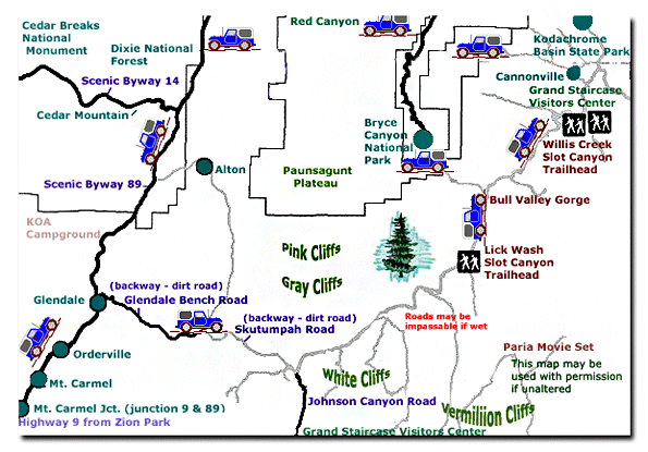
Grand Staircase-Escalante National Monument - UTAH!History of the Thunderbird |
East Zion Lodge Mileage from Stay in the heart of the parks, Mount Carmel Junction, and visit the treasures of the Southwest and Utah. Grand Staircase Skutumpah Road Cottonwood Road Hackberry Canyon Wahweap Hoodoos |
||||||||||||
|
This is my new favorite quote:
"I don't know who Mary Cisneros is, but I mean zionnational-park.com It's a better site than the NPS's anyway." Written by the authors of the book: Favorite Hikes in and around Zion National Park |
|||||||||||||


|
Zion History |
|---|
All rights reserved © Copyright Zion National-Park dot com
Do not use text, photos or maps without permission © Zion National-Park dot com
Contact the Author Mary Cisneros with any errors