border

Cedar Breaks National MonumentCedar Breaks - Utah

Located on the western edge of the Markagunt Plateau, this remote area offers no nearby dining or accommodations, so pack up a lunch when visiting Cedar Breaks. This Utah national monument offers refreshing summer temperatures to escape the hot Southwest desert. Cedar Breaks lodging is available on the east side of Zion National Park, Duck Creek or Cedar City.


Cedar Breaks
National Monument

Cedar Breaks is a magical world where sculpted hoodoos and fins shine in vivid, exposed colors. Due to the extreme erosion at Cedar Breaks the colors of the limestone formations have no equal. Color analysts have identified more than fifty different hues in the Cedar Breaks hoodoos.

Cedar Breaks Amphitheater

The Cedar Breaks amphitheater formed long ago, but even today the molding and sculpting continues. Powerful thunderstorms and snow storms rain down on the amphitheater, carving gullies for water to flow. Frigid cold winters forge away at the soft limestone rock and gravity pulls them down from the cliffs. These and many other forces combine to make Cedar Breaks the most beautiful and rapidly-eroding place in North America. Cedar Breaks National Monument is small compared to the nearby national parks, but it is not lacking scenery and adventure.

Cedar Breaks National Park, Utah Coral Pink Sand Dunes Map Grand Staircase-Escalante Map Bryce Canyon National Park Grand Canyon National Park, Arizona - North Rim Map Red Canyon, Dixie National Forest, Utah Lodging: Zion National Park Zion National Park Cedar Breks National Monument, Utah Dixie National Forest: Cedar Mountain Zion National Park Map Coral Pink Sand Dunes Map Zion National Park Lodging Cedar Breaks and Dixie National Forest Map Bryce Canyon and Red Canyon Map Grand Staircase-Escalante Map Zion National Park Map Coral Pink Sand Dunes Map Zion National Park Lodging Cedar Breaks and Dixie National Forest Map Grand Staircase-Escalante Map Bryce Canyon National Park Zion National Park Map Coral Pink Sand Dunes Map Zion National Park Lodging Cedar Breaks and Dixie National Forest Map Bryce Canyon and Red Canyon Map Grand Staircase-Escalante Map Zion National Park Map Coral Pink Sand Dunes Map Zion National Park Lodging Cedar Breaks and Dixie National Forest Map Bryce Canyon and Red Canyon Map Grand Staircase-Escalante Map Zion National Park Map Coral Pink Sand Dunes Map Zion National Park Lodging Cedar Breaks and Dixie National Forest Map Bryce Canyon and Red Canyon Map Grand Staircase-Escalante Map Zion National Park Map Coral Pink Sand Dunes Map Zion National Park Lodging Cedar Breaks and Dixie National Forest Map Bryce Canyon and Red Canyon Map Grand Staircase-Escalante Map Coral Pink Sand Dunes Map Grand Staircase-Escalante Map Bryce Canyon National Park Grand Canyon National Park, Arizona - North Rim Map Red Canyon, Dixie National Forest, Utah Lodging: Zion National Park Zion National Park Cedar Breks National Monument, Utah Dixie National Forest: Cedar Mountain Zion National Park Map Coral Pink Sand Dunes Map Zion National Park Lodging Cedar Breaks and Dixie National Forest Map Bryce Canyon and Red Canyon Map Grand Staircase-Escalante Map Zion National Park Map Coral Pink Sand Dunes Map Zion National Park Lodging Cedar Breaks and Dixie National Forest Map Grand Staircase-Escalante Map Bryce Canyon National Park Zion National Park Map Coral Pink Sand Dunes Map Zion National Park Lodging Cedar Breaks and Dixie National Forest Map Bryce Canyon and Red Canyon Map Grand Staircase-Escalante Map Zion National Park Map Coral Pink Sand Dunes Map Zion National Park Lodging Cedar Breaks and Dixie National Forest Map Bryce Canyon and Red Canyon Map Grand Staircase-Escalante Map Zion National Park Map Coral Pink Sand Dunes Map Zion National Park Lodging Cedar Breaks and Dixie National Forest Map Bryce Canyon and Red Canyon Map Grand Staircase-Escalante Map Zion National Park Map Coral Pink Sand Dunes Map Zion National Park Lodging Cedar Breaks and Dixie National Forest Map Bryce Canyon and Red Canyon Map Grand Staircase-Escalante Map Zion National Park Map Coral Pink Sand Dunes Map Zion National Park Lodging Cedar Breaks and Dixie National Forest Map Bryce Canyon and Red Canyon Map Grand Staircase-Escalante Map Favorite Hikes in and around Zion, including Cedar BreaksRoads to Cedar Breaks in the Winter
The remote location of Cedar Breaks, its snow blanketed plateaus and long winters limit the number of visitors to the monument. It keeps the park pristine, but due to the same factors, SR-148 closes each winter. Plan on the road being closed from late October or early November to late May.

Cedar Breaks Scenic Rim Drive
A five-mile rim drive leads to the four view points offered at Cedar Breaks. These include Spectra Point, Sunset View, Chessmen Ridge and Point Supreme. Point Supreme is where the Cedar Breaks Visitor Center is located and the ranger talks are held. Along the drive, meadows are visibly ablaze with wildflowers and forests of pine and quaking aspens thrive. Each of the monument's viewpoints reveal the three-mile span of the Cedar Breaks amphitheater as well as the 2500' depth.

Directions to Cedar Breaks

U-148 Closure Dates. U-148 to Cedar Breaks closes in the winter due to snow depth.

From Las Vegas: Take I-15 north to Cedar City. Take U-14 east from Cedar City to U-148 and turn left to Cedar Breaks.
From Arizona: Take US-89 north through Mount Carmel Junction and turn west on U-14. Turn right at U-148 to Cedar Breaks.
From Salt Lake City: Take I-15 south, exit at Parowan. Take U-143 to Cedar Breaks.
From Mount Carmel Junction: Take US-89 north to U-14. Follow U-14 to U-148 and Cedar Breaks.

Cedar Breaks Road Map - Cedar Mountain Map

Zion National Park Maps Map: Cedar Mountain - Dixie National Forest Southern Utah map Zion National Park Map - Overview of Zion Utah State Road 14 Utah State Road 148
 
Cedar Breaks National Park

Cedar Breaks National Monument bursts into a spectacular display of coral colored hoodoos each spring as the snow melts from the jagged rocks.


Lodging Zion National Park
Lodging Zion National ParkLodging and services are available on the gorgeous east side of Zion National Park, where guests are close to Zion National Park (12 miles), Bryce Canyon National Park (60 miles), Cedar Breaks National Monument (45 miles), Coral Pink Sand Dunes (12 miles), and the North Rim of the Grand Canyon (85 miles). It's where city traffic is absent and the skies are bright and clean.


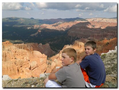
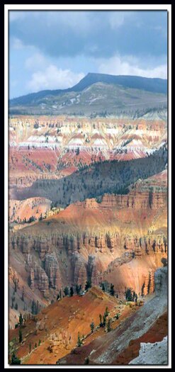
Cedar Breaks is breathtaking in its magnificence and it's non-commercial beauty is a gem
Although incredible, Cedar Breaks National Monument lies close to three world renowned national parks and as a result, it is often forgotten in rushed vacation plans. It is said that, "if Cedar Breaks were anywhere but in this Southwest region, it would be picked as one of the world's greatest scenic wonders."

Zion National Park, Bryce Canyon and the North Rim of the Grand Canyon are all just a short drive away. With a well planned itinerary a short southern Utah vacation can include all four attractions.

Utah's Dixie National Forest: Cedar Mountain
Cedar Breaks National Monument is surrounded by Utah's Dixie National Forest. From Mt. Carmel Junction, drive north on US-89 to the junction with SR-14. SR-14 is known as Cedar Mountain which is the scenic byway to travel to Cedar Breaks. Once on Cedar Mountain, travel through the beautiful forest, and then turn at the signed highway to Cedar Breaks - SR-148. It's 22 miles from Mt. Carmel Junction to boundary of Dixie National Forest and 45 miles to Cedar Breaks.

Utah's Dixie National Forest: Red Canyon
Red Canyon is a unique part of Dixie National Forest that is not only traveled through on the way to Bryce Canyon, but it has eroded hoodoos like Bryce Canyon and Cedar Breaks. It is found along Scenic Byway 12.


Web Southwest Parks


Share

Cedar Breaks National Monument, Utah

Best Western
East Zion Lodge

Reservations
1.888.848.6358

Zion Park Lodging

Zion National Park Lodging

East Zion Lodge
Vacation House
Group Lodging
East Zion Golf
East Zion RV Park
Vacation Packages
Business Retreat

Mileage from
Mt. Carmel Jct.

Zion National Park 12
Bryce Canyon 60
Grand Canyon 85
Cedar Breaks 45
Grand Staircase 9
Dixie Forest 22
Sand Dunes 11
Coyote Butte 57
Red Canyon 47
Tuweep 90

Stay in the heart of the parks, Mount Carmel Junction, and visit the treasures of the Southwest and Utah.

Site Map
Site Map II
Site Map III


Hiking Trails
Bartizan Arch
Spectra Point Trail
Ramparts Trail

Easy Trails
Cascade Falls
Bristlecone Pine
Alpine Pond

Cedar Breaks info
Visitor Center
Fees and passes
Ranger programs
Kid activities
Geology
History
Fauna
Flora

Cedar Breaks maps

Park map
Road map

This is my new favorite quote:
"I don't know who Mary Cisneros is, but I mean zionnational-park.com
It's a better site than the NPS's anyway."
Written by the authors of the book: Favorite Hikes in and around Zion National Park
Contact Mary to report errors:
 
border

Zion History
Zion Landmarks
Zion Geology
Zion Geology II
Zion Geology III
Zion Fauna

Zion Rock Art

Disclaimer & Privacy Policy
All rights reserved © Copyright Zion National-Park  dot com
Do not use text, photos or maps without permission © Zion National-Park dot com
Contact the Author Mary Cisneros
Bryce Canyon Map Zion National Park Map - Overview of Zion