border

Cedar Breaks Spectra Point Trail
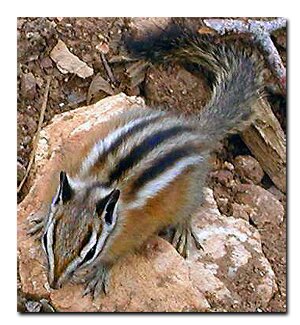
Cedar Breaks National Monument - Fauna

A variety of fauna have adapted to the elevation of Cedar Breaks, where a lofty 10,000' environment pushes the extremes. Many mammals live in the Cedar Breaks area including ground squirrels, pikas, marmots chipmunks and deer. Surviving, and thriving, in the extreme cold winters has resulted in the adaptation of unique characteristics.

Many of the animals commonly seen in the summer, hibernate though most of the bitter winter. Some mammals such as the marmot consume an enormous amount of food during the warm months of the year. This allows them to sleep throughout the winter.

The chipmunks and ground squirrels wake up once in a while to consume stored food. The rarely seen pika on the other hand, prefers to make its home on the high rocky slopes. It makes a warm blanket of cut grass and stays huddled in its hut until it is warm.

Cedar Breaks National Park, Utah Coral Pink Sand Dunes Map Grand Staircase-Escalante Map Bryce Canyon National Park Grand Canyon National Park, Arizona - North Rim Map Red Canyon, Dixie National Forest, Utah Lodging: Zion National Park Zion National Park Cedar Breks National Monument, Utah Dixie National Forest: Cedar Mountain Zion National Park Map Coral Pink Sand Dunes Map Zion National Park Lodging Cedar Breaks and Dixie National Forest Map Bryce Canyon and Red Canyon Map Grand Staircase-Escalante Map Zion National Park Map Coral Pink Sand Dunes Map Zion National Park Lodging Cedar Breaks and Dixie National Forest Map Grand Staircase-Escalante Map Bryce Canyon National Park Zion National Park Map Coral Pink Sand Dunes Map Zion National Park Lodging Cedar Breaks and Dixie National Forest Map Bryce Canyon and Red Canyon Map Grand Staircase-Escalante Map Zion National Park Map Coral Pink Sand Dunes Map Zion National Park Lodging Cedar Breaks and Dixie National Forest Map Bryce Canyon and Red Canyon Map Grand Staircase-Escalante Map Zion National Park Map Coral Pink Sand Dunes Map Zion National Park Lodging Cedar Breaks and Dixie National Forest Map Bryce Canyon and Red Canyon Map Grand Staircase-Escalante Map Coral Pink Sand Dunes Map Grand Staircase-Escalante Map Bryce Canyon National Park Grand Canyon National Park, Arizona - North Rim Map Red Canyon, Dixie National Forest, Utah Lodging: Zion National Park Zion National Park Cedar Breks National Monument, Utah Dixie National Forest: Cedar Mountain Zion National Park Map Coral Pink Sand Dunes Map Zion National Park Lodging Cedar Breaks and Dixie National Forest Map Bryce Canyon and Red Canyon Map Grand Staircase-Escalante Map Zion National Park Map Coral Pink Sand Dunes Map Zion National Park Lodging Cedar Breaks and Dixie National Forest Map Grand Staircase-Escalante Map Bryce Canyon National Park Zion National Park Map Coral Pink Sand Dunes Map Zion National Park Lodging Cedar Breaks and Dixie National Forest Map Bryce Canyon and Red Canyon Map Grand Staircase-Escalante Map Zion National Park Map Coral Pink Sand Dunes Map Zion National Park Lodging Cedar Breaks and Dixie National Forest Map Bryce Canyon and Red Canyon Map Grand Staircase-Escalante Map Zion National Park Map Coral Pink Sand Dunes Map Zion National Park Lodging Cedar Breaks and Dixie National Forest Map Bryce Canyon and Red Canyon Map Grand Staircase-Escalante Map Zion National Park Map Coral Pink Sand Dunes Map Zion National Park Lodging Cedar Breaks and Dixie National Forest Map Bryce Canyon and Red Canyon Map Grand Staircase-Escalante Map Favorite Hikes in and around Zion National ParkNature's Natural Tillers
Looking closely at the meadows in Cedar Breaks, you can find little heaps of dirt scattered about. These piles of soil are made by pocket gophers as they dig through the soil and pop their heads up above ground. This tilling of the soil is beneficial to the parks environment.

Other animals
The larger animals in the park include the black bear, mountain lion and mule deer and elk. The gray fox and coyote and bobcat are common, but elusive.   It's unlikely  visitors will ever see any of these animals.  The chipmunk is a common sight in the monument, as well as squirrels, and deer.   If you are lucky you might see the long-tailed weasel, red fox, or even a skunk.  Alpine Pond, a spring supplied  water source draws animals to it. The pond can be accessed by an easy hike that is popular with families.   

Directions to Cedar Breaks

U-148 Closure Dates. U-148 to Cedar Breaks closes in the winter due to snow depth.

From Las Vegas: Take I-15 north to Cedar City. Take U-14 east from Cedar City to U-148 and turn left to Cedar Breaks.
From Arizona: Take US-89 north through Mount Carmel Junction and turn west on U-14. Turn right at U-148 to Cedar Breaks.
From Salt Lake City: Take I-15 south, exit at Parowan. Take U-143 to Cedar Breaks.
From Mount Carmel Junction: Take US-89 north to U-14. Follow U-14 to U-148 and Cedar Breaks.

Cedar Breaks Road Map - Cedar Mountain Map

Zion National Park Maps Map: Cedar Mountain - Dixie National Forest Southern Utah map Zion National Park Map - Overview of Zion Utah State Road 14 Utah State Road 148
 
Cedar Breaks National Monument - fauna: Horney Toad

This little guy was a delightful treat that I saw while hiking in a deserted area of Cedar Breaks. Usually they will defend themselves by flattening their bodies, but this one posed for a picture.


Lodging Zion National Park
Lodging Zion National ParkLodging and services are available on the gorgeous east side of Zion National Park, where guests are close to Zion National Park (12 miles), Bryce Canyon National Park (60 miles), Cedar Breaks National Monument (45 miles), Coral Pink Sand Dunes (12 miles), and the North Rim of the Grand Canyon (85 miles). It's where city traffic is absent and the skies are bright and clean.

 
A deer seen on the Ashdown Gorge - Rattlesnake TrailThe bug killing the spruce trees
Look close at the trunks of many of the trees in Cedar Breaks and surrounding Dixie National Forest. You will see odd shapes or designs dug into the bark. These are beetle tracks. Normally, the beetles only attack dead trees, but when a beetle epidemic hits, large numbers of beetles kill the living trees as well. Although it may seem to be a problem, the killing of these trees makes room for new growth and is nature's way of keeping the forest healthy. The beetles are a native species to the forest, and nature will be allowed to run its course. In the 1920's, the spruce bark beetle killed the spruce trees on Boulder Mountain near Teasdale. The forest is now young and healthy.

Under normal conditions the spruce trees fight off the attack of the beetle, so the beetles are forced to be content with downed trees. When the beetles reach epidemic numbers they are able to kill healthy trees, overpowering the trees natural sap defense, especially if the trees are subject to drought. Dixie National Forest renews itself about every 300-500 years, but it's usually through the process of fire instead of a beetle epidemic. Recently another beetle, called the Fir Engraver, has been found in the forest and is attacking the Fir trees.

Utah's Dixie National Forest: Cedar Mountain
Cedar Breaks National Monument is surrounded by Utah's Dixie National Forest. From Mt. Carmel Junction, drive north on US-89 to the junction with SR-14. SR-14 is known as Cedar Mountain which is the scenic byway to travel to Cedar Breaks. Once on Cedar Mountain, travel through the beautiful forest, and then turn at the signed highway to Cedar Breaks - SR-148. It's 22 miles from Mt. Carmel Junction to boundary of Dixie National Forest and 45 miles to Cedar Breaks.

Utah's Dixie National Forest: Red Canyon
Red Canyon is a unique part of Dixie National Forest that is not only traveled through on the way to Bryce Canyon, but it has eroded hoodoos like Bryce Canyon and Cedar Breaks. It is found along Scenic Byway 12.


Web Southwest Parks


Share

Cedar Breaks National Monument, Utah

Best Western
East Zion Lodge

Reservations
1.888.848.6358

Zion Park Lodging

Zion National Park Lodging

East Zion Lodge
Vacation House
Group Lodging
East Zion Golf
East Zion RV Park
Vacation Packages
Business Retreat

Mileage from
Mt. Carmel Jct.

Zion National Park 12
Bryce Canyon 60
Grand Canyon 85
Cedar Breaks 45
Grand Staircase 9
Dixie Forest 22
Sand Dunes 11
Coyote Butte 57
Red Canyon 47
Tuweep 90

Stay in the heart of the parks, Mount Carmel Junction, and visit the treasures of the Southwest and Utah.

Site Map
Site Map II
Site Map III


Hiking Trails
Bartizan Arch
Spectra Point Trail
Ramparts Trail

Easy Trails
Cascade Falls
Bristlecone Pine
Alpine Pond

Cedar Breaks info
Visitor Center
Fees and passes
Ranger programs
Kid activities
History
Fauna
Flora

Cedar Breaks maps

Park map
Road map

This is my new favorite quote:
"I don't know who Mary Cisneros is, but I mean zionnational-park.com
It's a better site than the NPS's anyway."
Written by the authors of the book: Favorite Hikes in and around Zion National Park
Contact Mary to report errors:
 
border

Zion History
Zion Landmarks
Zion Geology
Zion Geology II
Zion Geology III
Zion Fauna

Zion Rock Art

Disclaimer & Privacy Policy
All rights reserved © Copyright Zion National-Park  dot com
Do not use text, photos or maps without permission © Zion National-Park dot com
Contact the Author Mary Cisneros
Bryce Canyon Map Zion National Park Map - Overview of Zion