Paria Canyon-Vermilion Cliffs Wilderness & Coyote Buttes Special Management Area
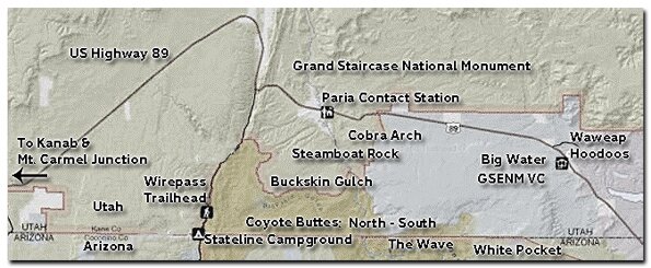
In 1984, congress created the 112, 500 acre Paria Canyon - Vermilion Cliffs Wilderness. In 1996, almost two-million acres of Southern Utah land was designated as the Grand Staircase-Escalante National Monument. Four years later, bordering Arizona land was designated as the Vermillion Cliffs National Monument. Paria Canyon is in Utah, and it contains the spectacular Coyote Buttes Special Management Area. The Utah area is what this site will focus on. The notorious sandstone buttes known at the Wave sit at the bottom of Utah's Grand Staircase-Escalante National Monument and the upper section of Arizona's Paria Canyon-Vermilion Cliffs Wilderness. While many of the areas we provide information for can be explored without a permit, or by just getting an inexpensive permit at the trailhead, the Coyote Buttes section demands a permit obtain at least the morning before heading to the area.
Stateline Campground - Located at the border of Utah and Arizona
Drive 10 miles from US Highway 89 to the Stateline Campground. The site is open year-round and there are no fees. There are only 4 spots (3 drive and 1 walk in) so if you want to camp get a spot early. Two of the sights are in Utah and two are in Arizona. There is no water, but there are vault toilets, fire pits. Cell phone coverage in this area is poor to nonexistent depending on your service. Disbursed camping is allowed on the Arizona side of the border on existing paths. On the Utah side, check the GSENM camping rules.
Paria Canyon Wilderness Area - This area contains the Coyote Buttes Special Management Area, but others area as well. Buckskin Gulch is a spectacular, 13-mile long slot canyon (20 miles to the trailend) that can be done as a really long day hike or an overnight backpack. The hike can also be explored partially, by walking in and returning the way you came. It begins at the Wire Pass Trailhead on House Rock Road. Cobra Arch is a magnificent wonder, while White Pocket and Steamboat Rock and highly photographic assemblies of distorted rock formations.
Cobra Arch - Permit is not needed Buckskin Gulch - Get a permit at the trailhead for a day hike White Pocket - Best to combine with a South Coyote Buttes. Permit is not needed Steamboat Rock - Good to combine with South Coyote Buttes. Permit is not needed
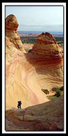
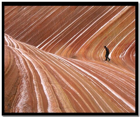
Coyote Buttes Special Management Area - This area sits at the upper section of the Paria Canyon Wilderness, and the bottom of Utah's Grand Staircase-Escalante National Monument. The Wave is highly popular, but a rugged summer hike due to the lack of shade. South Coyote Buttes is just as pretty, but a 4WD and the skills to drive such a vehicle are required. A permit is required to visit the Wave, Cottonwood Teepees and Paw Hole.
Road Conditions: House Rock Road (BLM Road 1065) from US Highway 89 to the Stateline Campground is impassible if wet, and a high clearance vehicle is suggested for travel at any time. It is subject to flash flood damage and there are no services. Be prepared for an overnight stay and vehicle repair.
Vermillion Cliffs Monument
345 E. Riverside Drive
St. George, UT 84790-6714
435-688-3200
Vermillion Cliffs National Monument
This is the administration entity for Paria Canyon Wilderness which includes Wire Pass, Buckskin Gulch, North and South Coyote Buttes special permit areas and the Paria River from US Highway 89 South. Paria Canyon Wilderness is bordered on the east by the Glen Canyon National Recreation Area: north and west of the state line (Az-Ut) bordered by the GSENM.
Paria Canyon Directions
From Mount Carmel Junction, drive 17 miles to Kanab. Leave Kanab, drive 40 miles east on US Highway 89. The turn-off is located on the south (right side coming from Kanab) side of the road. Its between mile markers 25 and 26, at a curve in the road, at the end of a guard rail. Turn at the unmarked dirt road. This is House Rock Road. Follow the road to your preferred trailhead. Directions to the Wave
South Coyote Buttes
Lodging and services are available on the gorgeous east side of Zion National Park, where guests are close to Zion National Park (12 miles), Bryce Canyon National Park (60 miles), Cedar Breaks National Monument (45 miles), Coral Pink Sand Dunes (12 miles), and the North Rim of the Grand Canyon (85 miles). It's where city traffic is absent and the skies are bright and clean.
Coyote Buttes Special Permit Offices
Arizona Strip Field Office: 345 East Riverside Drive St. George, Utah 84790 435-688-3200 Kanab Office: 318 N 100 E Kanab, Utah 84741 435.644.4600. Paria Contact Station: Located south of US Highway 89 between milepost 21 and 22,
between Kanab and Page, Arizona.
Paria Canyon Wilderness contains Coyote Buttes Special Management Area which was made popular by the Wave. The sandstone buttes sit at the bottom of Utah's Grand Staircase-Escalante National Monument and the upper section of Arizona's Paria Canyon Wilderness.
Mileage from
Mt. Carmel Jct.
Zion National Park 12
Bryce Canyon 60
Grand Canyon 85
Cedar Breaks 45
Grand Staircase 9
Dixie Forest 22
Sand Dunes 11
Coyote Butte 57
Red Canyon 47
Tuweep 90
Stay in the heart of the parks, Mount Carmel Junction, and visit the treasures of the Southwest and Utah.


 Paria Canyon-Vermilion Cliffs Wilderness & Coyote Buttes Special Management Area