|
|
 |
|||
|
Staircase | Lodging | Camping | Maps | Coyote Buttes | Weather | Hiking | Backpack | Hwy 89 | Vacation | Pictures |
||||

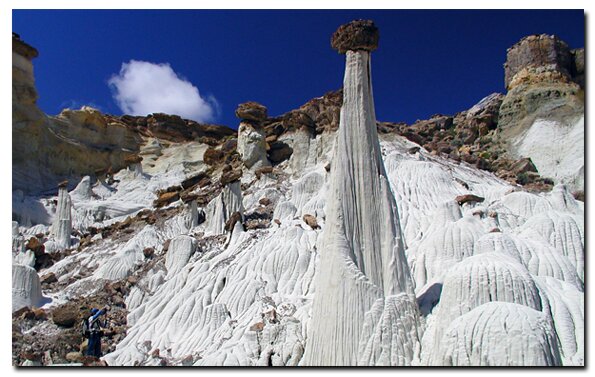
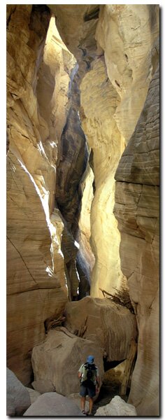
Grand Staircase-Escalante National Monument, UtahThe Grand Staircase Escalante National Monument is a huge chunk of public land engulfing much of the Southwestern Utah desert. The national monument is a 1.9 million acre (1,870,800 federal/15,000 privately owned) oasis of mostly primitive land strewn with streams, monoliths, slot canyons and scientific treasures galore. This parcel of land dominates the rural southern section of the state of Utah, protecting as much as two-hundred-million years of history within its boundaries. This vast oasis provides a record of geological, biological, paleontological and archeological data that will be used to fill many text books in our future. The remote and pristine Grand Staircase-Escalante has preserved a wealth of original populations of flora, fauna, new species of dinosaurs and Ancestral Puebloan (Anasazi) artifacts.
Boundaries of the Grand Staircase Escalante - The boundaries of Utah's Kane County and Garfield County enclose the monument lands. Kane County claims 68% of the monument and Garfield County holds 32%.
The enchantment of nature is abundant in Utah, where nearly eighty-percent of the state is land administered for public use, by federal and state agencies. Zion National Park, Bryce Canyon, Cedar Breaks and the Grand Staircase-Escalante share a common sanctuary in the vast desert of southern Utah. Each national treasure has its own unique display of rock sculptures to share. The North Rim of the Grand Canyon in the far north section of Arizona also dips its boundaries into the geologic framework of the Grand Staircase. Stepping onto the Grand Staircase EscalanteIn the 1870s, geologist Clarence Dutton described the Grand Staircase as a "huge stairway ascending out of the bottom of the Grand Canyon northward with the cliff edge of each layer forming giant steps." The steps rise 5500' from the floor of the Grand Canyon to the edge of the jagged Paunsaugunt Plateau at Bryce Canyon. The distinct steps are the Vermilion Cliffs, the White Cliffs, the Gray Cliffs and the Pink Cliffs.
Grand Staircase-Escalante Roads - Pristine and remote describes the roadways within the Grand Staircase Escalante National Monument. Highway 89 defines the southern border and Highway 12 accesses the northern side. In addition to Highways 12 and 89, there are 959 miles of open road in the Grand Staircase. Glendale, Utah, located on Highway 89, northeast of Zion National Park, connects the east side of Zion to Bryce Canyon via the Glendale Bench Road and the scenic backway, Skutumpah Road. To the north, Highway 12 connects Tropic and Boulder, Utah. At the southern end of the monument, roads connect Kanab, Utah and Page, Arizona. The most popular roads in the Grand Staircase are probably Skutumpah Road accessed either by the Glendale Bench Road, near the east entrance to Zion, or the Johnson Canyon Road near Kanab, both leading to Kodachrome Basin near Bryce Canyon. All interior roads except for portions of the Burr Trail and Johnson Canyon Road are unpaved and become slippery and impassible if wet. 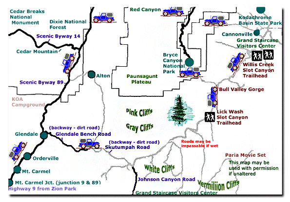
Grand Staircase-Escalante National Monument - UTAH!History of the Thunderbird |
East Zion Lodge Mileage from Stay in the heart of the parks, Mount Carmel Junction, and visit the treasures of the Southwest and Utah. Grand Staircase Skutumpah Road Cottonwood Road Hackberry Canyon Wahweap Hoodoos |
||||||||||||
|
This is my new favorite quote:
"I don't know who Mary Cisneros is, but I mean zionnational-park.com It's a better site than the NPS's anyway." Written by the authors of the book: Favorite Hikes in and around Zion National Park |
|||||||||||||


|
Zion History |
|---|
All rights reserved © Copyright Zion National-Park dot com
Do not use text, photos or maps without permission © Zion National-Park dot com
Contact the Author Mary Cisneros with any errors