|
|
 |
|||
|
Staircase | Lodging | Camping | Maps | Coyote Buttes | Weather | Hiking | Backpack | Hwy 89 | Vacation | Pictures |
||||

Landmarks in the Grand Staircase-Escalante National Monument, Utah
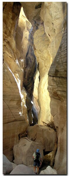
Cottonwood Canyon - This is a little slot canyon located along Cottonwood Road. It's close to the road, but easy to miss. Set your odometer after turning off Highway 89. Its about 25 miles. It's also about 4 miles south of the turn-off to Grosvenor Arch. Starlight Arch - Starlight Arch is located west of the Paria Movie Set. There is no established trail to the arch, but it can be accessed by hiking up the Paria River. Paria Movie Set - The old buildings were located 5 miles northeast of highway 89. The set was constructed in the 1960s and made famous by John Wayne, Gregory Peck and Clint Eastwood. Sadly the Paria Movie Set was vandalized and burned down late in 2006. Grosvenor Arch - This magnificent double arch is 30 miles from the turn off from highway 89 and 19 miles from Cannonville. Take the Cottonwood Canyon road to find the arch. Slot Canyons - Willis Creek, Lick Wash and Bull Valley Gorge are magnificent slot canyons located in the Grand Staircase. Take Skutumpah Road to find all three slot canyons. Wahweap Hoodoos - These delicate, towering white pillars seem as if they may wash away with the next storm. The hike to the hoodoos begins in the small town of Big Water, Utah. Paria means "muddy water" in the Paiute language.
Scenic roads in the Grand Staircase-Escalante National Monument are in the state of Utah. The primitive land of the Grand Staircase-Escalante National Monument is protected for our children and their children. The area is one big research site under guidance of the BLM.
Grand Staircase-Escalante Roads - Pristine and remote describes the roadways within the Grand Staircase Escalante National Monument. Highway 89 defines the southern border and Highway 12 accesses the northern side. In addition to Highways 12 and 89, there are 959 miles of open road in the Grand Staircase. Glendale, Utah, located on Highway 89, northeast of Zion National Park, connects the east side of Zion to Bryce Canyon via the Glendale Bench Road and the scenic backway, Skutumpah Road. To the north, Highway 12 connects Tropic and Boulder, Utah. At the southern end of the monument, roads connect Kanab, Utah and Page, Arizona. The most popular roads in the Grand Staircase are probably Skutumpah Road accessed either by the Glendale Bench Road, near the east entrance to Zion, or the Johnson Canyon Road near Kanab, both leading to Kodachrome Basin near Bryce Canyon. All interior roads except for portions of the Burr Trail and Johnson Canyon Road are unpaved and may be impassible if wet. 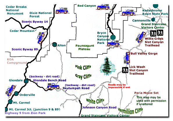
Grand Staircase-Escalante National Monument - UTAH!History of the Thunderbird |
East Zion Lodge Mileage from Stay in the heart of the parks, Mount Carmel Junction, and visit the treasures of the Southwest and Utah. Grand Staircase Skutumpah Road Cottonwood Road Hackberry Canyon Wahweap Hoodoos |
||||||||||||
|
This is my new favorite quote:
"I don't know who Mary Cisneros is, but I mean zionnational-park.com It's a better site than the NPS's anyway." Written by the authors of the book: Favorite Hikes in and around Zion National Park |
|||||||||||||
 Cottonwood Canyon Road: Although the entire Grand Staircase Escalante National Monument is in Southern Utah, the Cottonwood Canyon Road is close to the border of Arizona, near the Utah town of Big Water. The turn-off to Cottonwood Canyon Road is located on


|
Zion History |
|---|
All rights reserved © Copyright Zion National-Park dot com
Do not use text, photos or maps without permission © Zion National-Park dot com
Contact the Author Mary Cisneros with any errors