|
|
 |
|||
|
Staircase | Lodging | Camping | Maps | Coyote Buttes | Weather | Hiking | Backpack | Hwy 89 | Vacation | Pictures |
||||

Yellow Rock: Grand Staircase-Escalante National MonumentThis relatively short hike, just west of the Cottonwood Road in the Grand Staircase-Escalante National Monument, takes one to the top of a massive multicolored, swirling sandstone monolith. Although the summit of the "dome" is not towering above all others in the region, it nonetheless affords vistas for many miles that wet the palate and reward the eye with wonder! Even though the trek is a relatively short distance, the going requires some steep scrambling and is fairly strenuous. On the summit of Yellow Rock, topography unfolds to the north with Hackberry Wash just below, and beyond Castle Rocks vertical walls tower in the distance. The Paria River Gorge indents the plateau to the west and south, and the Cockscomb rises in the east. The hike is located north of Highway 89 on the Cottonwood Road in the GSENM.
Getting to Cottonwood Road - To locate Cottonwood Road, drive south from Mount Carmel Junction 17 miles to Kanab. From Kanab, drive east on Highway 89 toward Page. After crossing over the Paria River, soon the BLM Paria Contact and Information Center will be passed on the right. It is a short 3 mile drive from the station until Cottonwood Road is encountered on the north (left) of Highway 89. The road is marked and easy to find if you are looking for it. Cottonwood Road - Turn onto Cottonwood Road and set the trip meter. It is 14.4 miles to the unmarked parking area for Hackberry Wash. The parking is on the left side of the road. The drive up Cottonwood Road can be quite washboarded at times and other times it's a smooth dirt road. Look for the obvious left hand turn leading to a large parking area and the metal "podium style" register box. This is the trailhead for Hackberry Wash and Yellow Rock. Yellow Rock Trail - Sign in at the trail register and then locate the beaten path. Following the trail 15 yards to the west, down into Cottonwood Wash and cross to the west side. An obvious trail continues west, to the mouth of Hackberry Canyon Narrows, but it will be necessary to deviate from this trail and walk downstream in Cottonwood Wash for approximately 300-400 yards. Look for another wash entering from the steep terrain to the west.
Yellow Rock - Soon the path arrives at the massive yellow slickrock dome known as Yellow Rock. The easiest path to follow to the summit of Yellow Rock lays directly in front. There is not a formal trail to the summit, but by traversing back and forth (switchbacks), it is relatively easy to arrive at the summit without too much physical effort. On top of Yellow Rock, all of the effort expended is rewarded with magnificent views in all directions! Be sure to relax, take photos, have a snack and then prepare for the downhill hike back to the trailhead.
Side Canyon and 37°15.540 N 111°55.410 W Elevation 5500' GPS coordinates are only references and may or may not be accurate. Do not rely on GPS coordinates as the sole method of navigation. Always have an accurate, detailed map at hand and have the proper map reading and navigation skills before setting out on any hike. Many of the hikes listed in this guide travel into canyons where a GPS has limited capabilities. Always check your position with a detailed map before dropping into a canyon.
Grand Staircase-Escalante Roads - Pristine and remote describes the roadways within the Grand Staircase Escalante National Monument. Highway 89 defines the southern border and Highway 12 accesses the northern side. In addition to Highways 12 and 89, there are 959 miles of open road in the Grand Staircase. Glendale, Utah, located on Highway 89, northeast of Zion National Park, connects the east side of Zion to Bryce Canyon via the Glendale Bench Road and the scenic backway, Skutumpah Road. To the north, Highway 12 connects Tropic and Boulder, Utah. At the southern end of the monument, roads connect Kanab, Utah and Page, Arizona. The most popular roads in the Grand Staircase are probably Skutumpah Road accessed either by the Glendale Bench Road, near the east entrance to Zion, or the Johnson Canyon Road near Kanab, both leading to Kodachrome Basin near Bryce Canyon. All interior roads except for portions of the Burr Trail and Johnson Canyon Road are unpaved and may be impassible if wet. 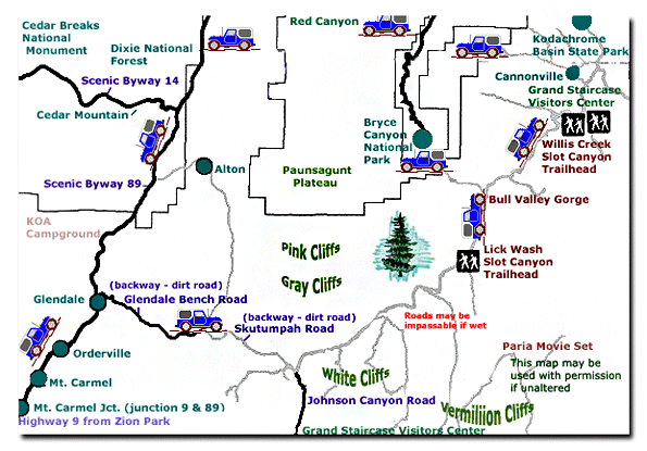
Grand Staircase-Escalante National Monument - UTAH!History of the Thunderbird |
East Zion Lodge Mileage from Stay in the heart of the parks, Mount Carmel Junction, and visit the treasures of the Southwest and Utah. Grand Staircase Skutumpah Road Cottonwood Road Hackberry Canyon Wahweap Hoodoos |
||||||||||||
|
This is my new favorite quote:
"I don't know who Mary Cisneros is, but I mean zionnational-park.com It's a better site than the NPS's anyway." Written by the authors of the book: Favorite Hikes in and around Zion National Park |
|||||||||||||
 Yellow Rock at a Glance
 GPS Coordinates WGS84 Datum
 Trailhead:


|
Zion History |
|---|
All rights reserved © Copyright Zion National-Park dot com
Do not use text, photos or maps without permission © Zion National-Park dot com
Contact the Author Mary Cisneros with any errors