|
|
 |
|||
|
Staircase | Lodging | Camping | Maps | Coyote Buttes | Weather | Hiking | Backpack | Hwy 89 | Vacation | Pictures |
||||

Roads through the Grand Staircase-Escalante National Monument, Utah
Climbing the Grand Staircase - The Grand Staircase is not your average staircase. The bottom layer is the deep bottom layer of Arizona's Grand Canyon and the pink hoodoos of Utah's Bryce Canyon are the top riser. When driving on 89A from the North Rim of the Grand Canyon, toward the Utah town of Kanab, all the visible steps of the Grand Staircase-Escalante can be seen at once. Borders of the Grand Staircase Escalante National Monument - The entire 1.9 million acres of the Grand Staircase-Escalante National Monument is in southern Utah. The monument is divided into three sections: The Grand Staircase, Kaiparowits Plateau and the Escalante Canyons. The Grand Staircase is a wonderful part of the monument that is surrounded by some of the most popular national parks in the country.
The Roads in the Grand Staircase-Escalante National Monument Bench Road (300 N) in Glendale, Utah. The Bench Road is located on Highway 89, 9 miles northeast of Mount Carmel Junction, on the east side of Zion National Park. This is a scenic and fun dirt road and 2WDs are fine if the roads are dry. The Bench Road is directly across the highway from the Buffalo Bistro in Glendale. The dirt road will intersect with Skutumpah at the 15 mile mark. map
Scenic Loop in the Grand Staircase Escalante From Zion National Park drive to the east side and out the east entrance. Continue to Mount Carmel Junction at the junction of highways 9 & 89. Drive 6 miles northeast toward Glendale. Enter the Grand Staircase Escalante at the Bench Road. It's directly across the highway from the Buffalo Bistro. Turn on Skutumpah Road and drive towards Cannonville. Along the way visit Bull Valley Gorge, Lick Wash and Willis Creek. Make sure to visit Bryce Canyon and Red Canyon before leaving the area. The road may be impassible if wet. Hiking near Big Water, Utah Hiking along Skutumpah Road
Gunsmoke Movie Set - Located on private land, so it's viewed from a distance. It's located just off the the Johnson Canyon road. Along Cottonwood Canyon Road Hackberry Canyon - A very nice hike down a stream to some dinosaur tracks. Yellow Rock - Exploration of a large, photogenic rock. Cottonwood Canyon - A short slot canyon the whole family can explore. Grosvenor Arch - Grosvenor Arch is an impressive sandstone double arch. Paria Movie Set - The Paria Movie Set is an old set where many 1960s movies were filmed. It's located 14 miles west of the Cottonwood Wash Road and highway 89 junction. Sadly vandals burned down the movie set in the fall of 2006.
Grand Staircase-Escalante Roads - Pristine and remote describes the roadways within the Grand Staircase Escalante National Monument. Highway 89 defines the southern border and Highway 12 accesses the northern side. In addition to Highways 12 and 89, there are 959 miles of open road in the Grand Staircase. Glendale, Utah, located on Highway 89, northeast of Zion National Park, connects the east side of Zion to Bryce Canyon via the Glendale Bench Road and the scenic backway, Skutumpah Road. To the north, Highway 12 connects Tropic and Boulder, Utah. At the southern end of the monument, roads connect Kanab, Utah and Page, Arizona. The most popular roads in the Grand Staircase are probably Skutumpah Road accessed either by the Glendale Bench Road, near the east entrance to Zion, or the Johnson Canyon Road near Kanab, both leading to Kodachrome Basin near Bryce Canyon. All interior roads except for portions of the Burr Trail and Johnson Canyon Road are unpaved and may be impassible if wet. 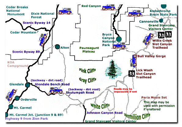
Grand Staircase-Escalante National Monument - UTAH!History of the Thunderbird |
East Zion Lodge Mileage from Stay in the heart of the parks, Mount Carmel Junction, and visit the treasures of the Southwest and Utah. Grand Staircase Skutumpah Road Cottonwood Road Hackberry Canyon Wahweap Hoodoos |
||||||||||||
|
This is my new favorite quote:
"I don't know who Mary Cisneros is, but I mean zionnational-park.com It's a better site than the NPS's anyway." Written by the authors of the book: Favorite Hikes in and around Zion National Park |
|||||||||||||
 The
The 
 Skutumpah Road - Also known as Road 500. Skutumpah captures the beauty of the Grand Staircase-Escalante National Monument with its rugged 34 mile dirt road that winds past some great slot canyon
  Johnson Canyon Road
 Cottonwood Canyon Road


|
Zion History |
|---|
All rights reserved © Copyright Zion National-Park dot com
Do not use text, photos or maps without permission © Zion National-Park dot com
Contact the Author Mary Cisneros with any errors