|
|
 |
|||
|
Staircase | Lodging | Camping | Maps | Coyote Buttes | Weather | Hiking | Backpack | Hwy 89 | Vacation | Pictures |
||||

Visitor Centers: Grand Staircase-Escalante National Monument, UtahThe BLM is setting up a kiosk near the Glendale entrance (Bench Road) into the Grand Staircase-Escalante. Existing Visitor Centers include: Kanab, Cannonville, Escalante, Big Water and Anasazi State Park. Cannonville Visitor Center - Cannonville's theme is on the early settler history. The building and the fence around it is a design from a vernacular stone house. Kanab Visitor Center - The Kanab Visitor Center, shown below, has a focus on "traces in time" which includes both geology and archeology. Phone: 435.644.4680
Big Water Visitor Center - The theme at the visitor center at Big Water is paleontology of the monument. The shape of the building is derived from an ammonite and the rockwork mimics the layers found in the sandstone cliffs nearby.
Paria Contact Station - Located on highway 89, 60 miles east of Mt. Carmel Junction. This is also the contact station for Paria Canyon. No phone Escalante Visitor Center - Located in Escalante. Phone: 435-826-5499 Anasazi State Park Visitor Center - Located in Anasazi State Park, along Highway 12 Phone: 435-335-7382
BLM Inventory Project - The BLM has the task of inventory of the species and habitats in the vast southern Utah wilderness of the Grand Staircase-Escalante National Monument. These studies are being done in conjunction with other state and government agencies as well as with various universities. Grand Staircase Biking - Bicycles are only allowed on designated public roads. Contact the visitor centers for approved routes in the area you are visiting. Permits are required for overnight camping. Leave no trace. If you packed it in, pack it out. Off-highway Vehicles (OHV) - ATVs are not allowed on hiking trails or to travel cross country, but over 900 miles of routes are open for use. Leave no trace. Do not drive on wet roads and leave gates as you find them. If you packed it in, pack it out. Check with the visitors center for roads open to ATV use in the area you are visiting.
Grand Staircase-Escalante Roads - Pristine and remote describes the roadways within the Grand Staircase Escalante National Monument. Highway 89 defines the southern border and Highway 12 accesses the northern side. In addition to Highways 12 and 89, there are 959 miles of open road in the Grand Staircase. Glendale, Utah, located on Highway 89, northeast of Zion National Park, connects the east side of Zion to Bryce Canyon via the Glendale Bench Road and the scenic backway, Skutumpah Road. To the north, Highway 12 connects Tropic and Boulder, Utah. At the southern end of the monument, roads connect Kanab, Utah and Page, Arizona. The most popular roads in the Grand Staircase are probably Skutumpah Road accessed either by the Glendale Bench Road, near the east entrance to Zion, or the Johnson Canyon Road near Kanab, both leading to Kodachrome Basin near Bryce Canyon. All interior roads except for portions of the Burr Trail and Johnson Canyon Road are unpaved and may be impassible if wet. 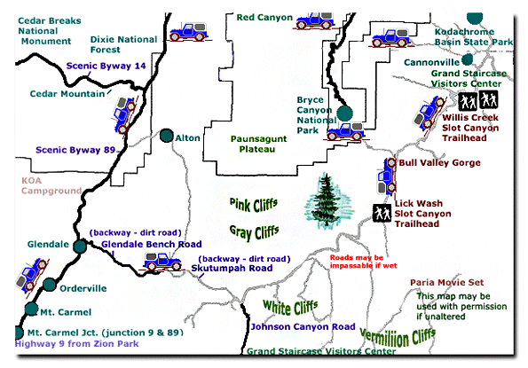
Grand Staircase-Escalante National Monument - UTAH!History of the Thunderbird |
East Zion Lodge Mileage from Stay in the heart of the parks, Mount Carmel Junction, and visit the treasures of the Southwest and Utah. Grand Staircase Skutumpah Road Cottonwood Road Hackberry Canyon Wahweap Hoodoos |
||||||||||||
|
This is my new favorite quote:
"I don't know who Mary Cisneros is, but I mean zionnational-park.com It's a better site than the NPS's anyway." Written by the authors of the book: Favorite Hikes in and around Zion National Park |
|||||||||||||


|
Zion History |
|---|
All rights reserved © Copyright Zion National-Park dot com
Do not use text, photos or maps without permission © Zion National-Park dot com
Contact the Author Mary Cisneros with any errors