|
|
 |
|||
|
Staircase | Lodging | Camping | Maps | Coyote Buttes | Weather | Hiking | Backpack | Hwy 89 | Vacation | Pictures |
||||

Flora of the Grand Staircase-Escalante National Monument, Utah
Isolation Protects Original Flora - The multi-hued landscape of badlands, buttes and canyons is a mecca of floral diversity. The lands are host to hardy pinyon pines, some over a thousand years old and also to fragile desert wild flowers. Sprouting from the soil, in the Grand Staircase Escalante, is over two-hundred million years of history. BLM scientist, Eaton, states that, "The isolation of the region has, for the most part, guaranteed the integrity of its original flora and fauna. 84% of the Flora in Utah is in the Staircase -Eighty-four percent of the flora of the state of Utah is found in the Grand Staircase and about fifty percent of the rare species in Utah. There are one-hundred-twenty five species of plants that are only found in Utah or the Colorado Plateau and eleven species are found nowhere else. However, Utah also has plants listed as threatened or endangered. The Southwestern location and the varied topography account for much of the diversity.
"The three reasons for the importance of wilderness: to protect the natural ecosystem and the life forms within it, to provide a scientific baseline for comparison with other landscapes, and to provide recreational, spiritual and other human values."
Grand Staircase-Escalante Roads - Pristine and remote describes the roadways within the Grand Staircase Escalante National Monument. Highway 89 defines the southern border and Highway 12 accesses the northern side. In addition to Highways 12 and 89, there are 959 miles of open road in the Grand Staircase. Glendale, Utah, located on Highway 89, northeast of Zion National Park, connects the east side of Zion to Bryce Canyon via the Glendale Bench Road and the scenic backway, Skutumpah Road. To the north, Highway 12 connects Tropic and Boulder, Utah. At the southern end of the monument, roads connect Kanab, Utah and Page, Arizona. The most popular roads in the Grand Staircase are probably Skutumpah Road accessed either by the Glendale Bench Road, near the east entrance to Zion, or the Johnson Canyon Road near Kanab, both leading to Kodachrome Basin near Bryce Canyon. All interior roads except for portions of the Burr Trail and Johnson Canyon Road are unpaved and may be impassible if wet. 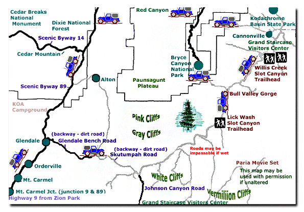
Grand Staircase-Escalante National Monument - UTAH!History of the Thunderbird |
East Zion Lodge Mileage from Stay in the heart of the parks, Mount Carmel Junction, and visit the treasures of the Southwest and Utah. Grand Staircase Skutumpah Road Cottonwood Road Hackberry Canyon Wahweap Hoodoos |
||||||||||||
|
This is my new favorite quote:
"I don't know who Mary Cisneros is, but I mean zionnational-park.com It's a better site than the NPS's anyway." Written by the authors of the book: Favorite Hikes in and around Zion National Park |
|||||||||||||
 Diverse, unique and even ancient are used to describe the flora of the Grand Staircase-Escalante National Monument. The Paria River flows through the monument creating an environment for life to thrive. The vast land covers five different life zones and thus is home to a large number of endemic species. Over one-hundred species of plants exist only on the Colorado Plateau or in the state of Utah. Many of the plants, (approximately 180), are either endangered or on a watch list.


|
Zion History |
|---|
All rights reserved © Copyright Zion National-Park dot com
Do not use text, photos or maps without permission © Zion National-Park dot com
Contact the Author Mary Cisneros with any errors