border

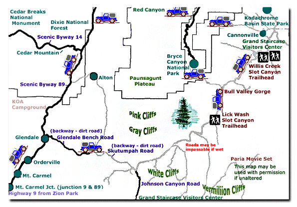
Hackberry Canyon: Grand Staircase-Escalante National Monument


Hackberry Canyon is a tributary of Cottonwood Creek, which eventually joins the Paria River. The trailhead for Hackberry Canyon is 14 miles up the Cottonwood Road, north of Highway 89, in the Grand Staircase-Escalante National Monument. This charming hike up a narrow slot canyon is reminiscent of many of the slot canyons that make Southern Utah famous for its slot canyon hiking. What sets this hike apart from some of the other slot canyon hikes is its remote setting and the refreshing gentle flow of spring water in the sandy canyon floor. This is a fun hike, welcoming the unseasoned hiker, yet offering a true wilderness experience.

Photo Album: Hackberry Canyon Photos
Trail Map: Hackberry Map
Day Hike: Yes.
Trail Distance: 2.1 miles one way to the dino tracks.
Average Hiking Time: 4 hours round trip.
Equipment: Hiking shoes that drain water well, 2 quarts of water per person, GPS to locate the dinosaur tracks, sun protective clothing.
Trail Usage: Cottonwood Road is impassible if wet.
Difficulty: Moderate
Sun Exposure: Full sun
Permits: No
Trail Conditions: Hackberry Canyon is a nice stroll through a sandy stream. This is an easy hike that kids and families with enjoy.
Trailhead: Cottonwood Road
Trailend: Same as trailhead
Elevation Gain: 125'
Best Season:
Spring and Fall. Anytime the water is running
Off the Beaten Path: Yes
Restrooms: None

To locate Cottonwood Road, drive south from Mount Carmel Junction, 17 miles to Kanab. From Kanab, drive east on Highway 89 toward Page. After crossing over the Paria River, the BLM Paria Contact and Information Center will soon be passed on the right. It is a 3 mile drive from the station to Cottonwood Road. Cottonwood Road is on the north (left) side of Highway 89 and marked by signage.

Set your trip meter as soon as you turn onto Cottonwood Road. It is 14.4 miles to the parking area for Hackberry Wash. There is no sign, but look for a small dirt turn-off on the left side of the road. The drive up Cottonwood Road may be quite washboarded. Cottonwood Road is impassible if wet.

From the parking area walk to the west and immediately drop into the wash below. Locate the cairned path through the willows to the west. Soon Hackberry Canyon is entered after walking .25 miles to the west. The walls begin to rise as the canyon narrows. Trying to keep shoes dry is a futile effort if the water is flowing. Walking in the sandy creek becomes easiest and quite refreshing. After .75 miles a large rock tower becomes quite the impressive landmark. The narrows are about 1.25 miles in length before the canyon walls separate and expose an ever widening valley.

Continuing another .75 mile looking on the left bank, just above the wash floor, for a wide bench with a few scattered boulders. This is where the dinosaur tracks are found. The boulder is fairly small (3' wide x 5' long and 2' high) but contains possibly 8 or more obvious Grallator (dinosaur) tracks. This is a good area to have lunch and take a break for the hike back.

Map: Zion National Park Coral Pink Sand Dunes Map Grand Staircase-Escalante Map Bryce Canyon National Park Grand Canyon National Park, Arizona - North Rim Map Red Canyon, Dixie National Forest, Utah Lodging: Zion National Park Zion National Park Cedar Breks National Monument, Utah Dixie National Forest: Cedar Mountain Zion National Park Map Coral Pink Sand Dunes Map Zion National Park Lodging Cedar Breaks and Dixie National Forest Map Bryce Canyon and Red Canyon Map Grand Staircase-Escalante Map Zion National Park Map Coral Pink Sand Dunes Map Zion National Park Lodging Cedar Breaks and Dixie National Forest Map Grand Staircase-Escalante Map Bryce Canyon National Park Zion National Park Map Coral Pink Sand Dunes Map Zion National Park Lodging Cedar Breaks and Dixie National Forest Map Bryce Canyon and Red Canyon Map Grand Staircase-Escalante Map Zion National Park Map Coral Pink Sand Dunes Map Zion National Park Lodging Cedar Breaks and Dixie National Forest Map Grand Staircase-Escalante Map Bryce Canyon National Park Zion National Park Map Coral Pink Sand Dunes Map Zion National Park Lodging Cedar Breaks and Dixie National Forest Map Bryce Canyon and Red Canyon Map Grand Staircase-Escalante Map Zion National Park Map Coral Pink Sand Dunes Map Zion National Park Lodging Cedar Breaks and Dixie National Forest Map Bryce Canyon and Red Canyon Map Grand Staircase-Escalante Map Zion National Park Map Coral Pink Sand Dunes Map Zion National Park Lodging Cedar Breaks and Dixie National Forest Map Grand Staircase-Escalante Map Bryce Canyon National Park Zion National Park Map Coral Pink Sand Dunes Map Zion National Park Lodging Cedar Breaks and Dixie National Forest Map Bryce Canyon and Red Canyon Map Grand Staircase-Escalante Map Zion National Park Map Coral Pink Sand Dunes Map Zion National Park Lodging Cedar Breaks and Dixie National Forest Map Grand Staircase-Escalante Map Bryce Canyon National Park Zion National Park Map Coral Pink Sand Dunes Map Zion National Park Lodging Cedar Breaks and Dixie National Forest Map Bryce Canyon and Red Canyon Map Grand Staircase-Escalante Map Zion National Park Map Coral Pink Sand Dunes Map Zion National Park Lodging Cedar Breaks and Dixie National Forest Map Bryce Canyon and Red Canyon Map Grand Staircase-Escalante Map Zion National Park Map Coral Pink Sand Dunes Map Zion National Park Lodging Cedar Breaks and Dixie National Forest Map Bryce Canyon and Red Canyon Map Grand Staircase-Escalante Map

zion National Park CanyoneeringGPS Coordinates
WGS84 Datum

Hackberry Canyon Parking
37°15.400 N
111°54.554 W

Tall Stone Pillar
37°15.870 N
11° 55.562 W

Dinosaur Tracks
37°16.208 N
111°56.213 W


Directions: East Zion to the
Grand Staircase-Escalante National Monument

Grand Staircase Map
Grand Staircase Road Map

From Salt Lake City, travel south on I15 to U-20. Exit on U-20. Turn south on U-89 and follow U-89 to Glendale.

From Las Vegas: Travel I15 to exit 16. Follow U-9 to the south entrance of Zion and through to the east entrance. Take U-9 for 12 miles to Mt. Carmel Jct, where U-89 and U-9 meet. Drive north on U-89 to Glendale. From Glendale, turn right on 300 N. (Bench Road) Follow the graded dirt road, Skutumpah, into the Grand Staircase. Remember the Grand Staircase is a wild and remote place. The dirt roads may be impassible when wet and there is usually no water, services or cell phone access. Skutumpah is a backway and should only be traveled in dry conditions. Call for road and weather information before travel: 435.644.4680

Zion National Park Maps
 
Dinosaur footprints found in Cottonwood Canyon of the Grand Staircase National Monument

Dinosaur tracks are found in the canyons;


Lodging Zion National Park
Lodging Zion National ParkLodging and services are available on the gorgeous east side of Zion National Park, where guests are close to Zion National Park (12 miles), Bryce Canyon National Park (60 miles), Cedar Breaks National Monument (45 miles), Coral Pink Sand Dunes (12 miles), and the North Rim of the Grand Canyon (85 miles). It's where city traffic is absent and the skies are bright and clean.


Zion Book: Favorite Hikes in and around Zion National Park including the GSENMGrand Staircase-Escalante Roads - Pristine and remote describes the roadways within the Grand Staircase Escalante National Monument. Highway 89 defines the southern border and Highway 12 accesses the northern side. In addition to Highways 12 and 89, there are 959 miles of open road in the Grand Staircase. Glendale, Utah, located on Highway 89, northeast of Zion National Park, connects the east side of Zion to Bryce Canyon via the Glendale Bench Road and the scenic backway, Skutumpah Road. To the north, Highway 12 connects Tropic and Boulder, Utah. At the southern end of the monument, roads connect Kanab, Utah and Page, Arizona. The most popular roads in the Grand Staircase are probably Skutumpah Road accessed either by the Glendale Bench Road, near the east entrance to Zion, or the Johnson Canyon Road near Kanab, both leading to Kodachrome Basin near Bryce Canyon. All interior roads except for portions of the Burr Trail and Johnson Canyon Road are unpaved and may be impassible if wet.

Map Grand Staircase National Monument Zion National Park Map Coral Pink Sand Dunes Map Zion National Park Lodging Cedar Breaks and Dixie National Forest Map Bryce Canyon and Red Canyon Map Grand Staircase-Escalante Map Zion National Park Map Coral Pink Sand Dunes Map Zion National Park Lodging Cedar Breaks and Dixie National Forest Map Grand Staircase-Escalante Map Bryce Canyon National Park Zion National Park Map Coral Pink Sand Dunes Map Zion National Park Lodging Cedar Breaks and Dixie National Forest Map Bryce Canyon and Red Canyon Map Grand Staircase-Escalante Map Zion National Park Map Coral Pink Sand Dunes Map Zion National Park Lodging Cedar Breaks and Dixie National Forest Map Grand Staircase-Escalante Map Bryce Canyon National Park Zion National Park Map Coral Pink Sand Dunes Map Zion National Park Lodging Cedar Breaks and Dixie National Forest Map Bryce Canyon and Red Canyon Map Grand Staircase-Escalante Map Zion National Park Map Coral Pink Sand Dunes Map Zion National Park Lodging Cedar Breaks and Dixie National Forest Map Bryce Canyon and Red Canyon Map Grand Staircase-Escalante Map Zion National Park Map Coral Pink Sand Dunes Map Zion National Park Lodging Cedar Breaks and Dixie National Forest Map Grand Staircase-Escalante Map Bryce Canyon National Park Zion National Park Map Coral Pink Sand Dunes Map Zion National Park Lodging Cedar Breaks and Dixie National Forest Map Bryce Canyon and Red Canyon Map Grand Staircase-Escalante Map Zion National Park Map Coral Pink Sand Dunes Map Zion National Park Lodging Cedar Breaks and Dixie National Forest Map Grand Staircase-Escalante Map Bryce Canyon National Park Zion National Park Map Coral Pink Sand Dunes Map Zion National Park Lodging Cedar Breaks and Dixie National Forest Map Bryce Canyon and Red Canyon Map Grand Staircase-Escalante Map Zion National Park Map Coral Pink Sand Dunes Map Zion National Park Lodging Cedar Breaks and Dixie National Forest Map Bryce Canyon and Red Canyon Map Grand Staircase-Escalante Map Zion National Park Map Coral Pink Sand Dunes Map Zion National Park Lodging Cedar Breaks and Dixie National Forest Map Bryce Canyon and Red Canyon Map Grand Staircase-Escalante Map

Share


Web Southwest Parks


Grand Staircase-Escalante National Monument - UTAH!


History of the Thunderbird

Best Western
East Zion Lodge

Reservations
1.888.848.6358

Zion Park Lodging

Zion National Park Lodging

East Zion Lodge
Vacation House
Group Lodging
East Zion Golf
East Zion RV Park
Vacation Packages
Family Reunion
Bus Tours
Business Retreat

Mileage from
Mt. Carmel Jct.

Zion National Park 12
Bryce Canyon 60
Grand Canyon 85
Cedar Breaks 45
Grand Staircase 9
Dixie Forest 22
Sand Dunes 11
Coyote Butte 57
Red Canyon 47
Tuweep 90

Stay in the heart of the parks, Mount Carmel Junction, and visit the treasures of the Southwest and Utah.

Site Map
Site Map II
Site Map III

Grand Staircase
National Monument
Visitor Centers
Roads in the Staircase
Landmarks
History
Fauna
Flora
Geology
For Kids

Skutumpah Road
Willis Creek

Lick Wash
Bull Valley Gorge

Cottonwood Road Hackberry Canyon
Yellow Rock
Cottonwood Canyon
Round Valley Draw

Wahweap
Wahweap Hoodoos
This is my new favorite quote:
"I don't know who Mary Cisneros is, but I mean zionnational-park.com
It's a better site than the NPS's anyway."
Written by the authors of the book: Favorite Hikes in and around Zion National Park
 
border

Zion History
Zion Landmarks
Zion Geology
Zion Geology II
Zion Geology III
Zion Fauna

Zion Rock Art

Disclaimer & Privacy Policy
All rights reserved © Copyright Zion National-Park  dot com
Do not use text, photos or maps without permission © Zion National-Park dot com
Contact the Author Mary Cisneros with any errors
Map of the Grand Staircase-Escalante National Monument Road Map to the Grand Staircase-Escalante National Monument Roads of the Grand Staircase-Escalante National Monument Visitor Centers: Grand Staircase-Escalante National Monument