border

Round Valley Draw: Grand Staircase-Escalante National Monument


Round Valley Draw is a slot canyon that does not require major equipment, logistics and it not not have a physically demanding approach. Narrow passageways, fluted dryfalls, multi-colored swirling, and striated weather worn sandstone formations are the faire for this moderately strenuous canyoneering experience. A couple quarts of water, some snacks, a map, some sticky-soled shoes and maybe a short chunk of rope, and of course a camera will pretty much sum up the needs for this short loop hike.

Round Valley Draw
Photo Album:
Round Valley Draw Pictures
Trail Maps:
Round Valley Draw Map

Day Hike:
Yes
Distance:
2.75 miles round trip
Average Hiking Time:
4 hours
Equipment: Plenty of water, sturdy hiking shoes, hat
ACA Canyon Rating: AI
Difficulty: There are some easier dlownclimbs and usually a rope will not be needed, but always bring a rope when doing slot canyons since conditions change rapidly. This is a wonderful slot canyon located just off Cottonwood Road in the Grand Staircase.
Elevation: General 400' descent and ascent
Permits: Not required. Check the weather report before hiking this trail. Do not hike if it looks like rain
Trailhead: Cottonwood Canyon Road
Trailend: Same as trailhead
Trail Access: Winter road conditions will deter most hikers in the winter months. Cottonwood Canyon road is slippery in the winter and impassible if there is snow or melting snow on the road. It is best to visit the GSENM during the summer and fall.
Off the Beaten Path: Yes
Best Season: Whenever Cottonwood road is accessible.
Check weather conditions prior to the hike. Hiking in slot canyons presents a very real danger from flash flooding. Do not hike this trail if it is raining. Remember a storm far off can trigger a flash flood.

Driving Instructions - Drive north on Highway 89, from Mt. Carmel Junction, to Route 12 and turn right toward Bryce Canyon National Park. Continue past Bryce, through Red Canyon, passing the small community of Tropic. Once in Cannonville turn right onto Cottonwood Road. The road will be paved for the first 6.4 miles, passing over the Paria River at about the 3 mile mark and then arriving at Kodachrome State Park. Cottonwood Road will now be dirt for the next 6.6 miles until it arrives at Round Valley Draw and GSENM Road #422 or as it is also called: Rushbed Road. This is where it will be necessary to turn right. Travel this high clearance vehicle road for 1.6 miles as it follows the wash bottom and then climbs south out of the wash bottom toward the trailhead and register perched just 50 yards out of the bottom of Round Valley Draw. If you have a 4WD it is possible to forgo parking at the official trailhead and continue west down the wash for another .75 miles to a large pine tree where the road ends. This option puts hikers directly above the start of the slot canyon.

Round Valley Draw - The slot canyon begins immediately with a 6' chimney downclimb followed by another 15' downclimb. For the next 1.25 miles Round Valley Draw opens and closes from a mere 18' wide to over 100' wide. There are several short down-climbs where lesser experienced hikers may desire a handline. The bottom of the canyon contains a large amount of clay content in various places, so recent rains may make travel wet (maybe wading) and very slippery. Be sure to take your time and take photos, as this is a truly beautiful Southern Utah slot canyon.

GPS Coordinates WGS84 Datum

Parking at Official Trailhead
37 27.381 N
111 54.046 W

Parking at Pine Trees
37 27.186 N
111 54.674 W

Exit from Slot Canyon
37 26.700 N
111 55.569 W

zion National Park CanyoneeringExit: Descent Route
into North Fork of
Round Valley Draw
37 27.196 N
111 54.978 W

Hoodoos
37 27.178 N
111 54.812 W

Map: Zion National Park Coral Pink Sand Dunes Map Grand Staircase-Escalante Map Bryce Canyon National Park Grand Canyon National Park, Arizona - North Rim Map Red Canyon, Dixie National Forest, Utah Lodging: Zion National Park Zion National Park Cedar Breks National Monument, Utah Dixie National Forest: Cedar Mountain Zion National Park Map Coral Pink Sand Dunes Map Zion National Park Lodging Cedar Breaks and Dixie National Forest Map Bryce Canyon and Red Canyon Map Grand Staircase-Escalante Map Zion National Park Map Coral Pink Sand Dunes Map Zion National Park Lodging Cedar Breaks and Dixie National Forest Map Grand Staircase-Escalante Map Bryce Canyon National Park Zion National Park Map Coral Pink Sand Dunes Map Zion National Park Lodging Cedar Breaks and Dixie National Forest Map Bryce Canyon and Red Canyon Map Grand Staircase-Escalante Map Zion National Park Map Coral Pink Sand Dunes Map Zion National Park Lodging Cedar Breaks and Dixie National Forest Map Grand Staircase-Escalante Map Bryce Canyon National Park Zion National Park Map Coral Pink Sand Dunes Map Zion National Park Lodging Cedar Breaks and Dixie National Forest Map Bryce Canyon and Red Canyon Map Grand Staircase-Escalante Map Zion National Park Map Coral Pink Sand Dunes Map Zion National Park Lodging Cedar Breaks and Dixie National Forest Map Bryce Canyon and Red Canyon Map Grand Staircase-Escalante Map Zion National Park Map Coral Pink Sand Dunes Map Zion National Park Lodging Cedar Breaks and Dixie National Forest Map Grand Staircase-Escalante Map Bryce Canyon National Park Zion National Park Map Coral Pink Sand Dunes Map Zion National Park Lodging Cedar Breaks and Dixie National Forest Map Bryce Canyon and Red Canyon Map Grand Staircase-Escalante Map Zion National Park Map Coral Pink Sand Dunes Map Zion National Park Lodging Cedar Breaks and Dixie National Forest Map Grand Staircase-Escalante Map Bryce Canyon National Park Zion National Park Map Coral Pink Sand Dunes Map Zion National Park Lodging Cedar Breaks and Dixie National Forest Map Bryce Canyon and Red Canyon Map Grand Staircase-Escalante Map Zion National Park Map Coral Pink Sand Dunes Map Zion National Park Lodging Cedar Breaks and Dixie National Forest Map Bryce Canyon and Red Canyon Map Grand Staircase-Escalante Map Zion National Park Map Coral Pink Sand Dunes Map Zion National Park Lodging Cedar Breaks and Dixie National Forest Map Bryce Canyon and Red Canyon Map Grand Staircase-Escalante Map Zion Book: Favorite Hikes in and around Zion National Park including the GSENMExit - After a dark section of the hike, the canyon will open up somewhat and there will be a fir tree on the left and some pinion trees on the right, at the mouth of a canyon, entering from hikers right. This is the exit for the day hike.

Note: The authors thought this would be an easy canyon to turn around and climb back out, but we did not try it because we wanted to check out the exit.  It does look like the fun way to exit however!

The travel up the side canyon is steep and loose but well marked and worn. After .25 miles of climbing, a plateau is reached. At the top is a road that can be followed for a very short distance before steering east across the plateau keeping closer to the rim of Round Valley Draw. Contour around a small side canyon and soon you will be confronted with a large canyon - the North Fork of Round Valley Draw. Pick the easiest travel into the bottom of this large canyon and then travel toward the 20' high hoodoos on the opposite side. Skirt around the south side of the hoodoos and continue east and work toward the bottom of Round Valley Draw. If your vehicle was parked at the pine tree rather than the trailhead and register, then it will come into view very soon. Find the weakness that allows crossing down and over to your vehicle. Total round-trip distance for this hike from the pine tree parking is 2.75 miles and 4.25 miles if parking at the trailhead and register. Total descent through the canyon is about 250', but the ascent out is about 400' and then a descent of 150' back down to the vehicle.

Directions: East Zion to the
Grand Staircase-Escalante National Monument

Grand Staircase Map
Grand Staircase Road Map

From Salt Lake City, travel south on I15 to U-20. Exit on U-20. Turn south on U-89 and follow U-89 to Glendale.

From Las Vegas: Travel I15 to exit 16. Follow U-9 to the south entrance of Zion and through to the east entrance. Take U-9 for 12 miles to Mt. Carmel Jct, where U-89 and U-9 meet. Drive north on U-89 to Glendale. From Glendale, turn right on 300 N. (Bench Road) Follow the graded dirt road, Skutumpah, into the Grand Staircase. Remember the Grand Staircase is a wild and remote place. The dirt roads may be impassible when wet and there is usually no water, services or cell phone access. Skutumpah is a backway and should only be traveled in dry conditions. Call for road and weather information before travel: 435.644.4680

Zion National Park Maps
 
Round Valley Draw in the Grand Staircase National Monument

Round Valley Draw in the Grand Staircase National Monument


Lodging Zion National Park
Lodging Zion National ParkLodging and services are available on the gorgeous east side of Zion National Park, where guests are close to Zion National Park (12 miles), Bryce Canyon National Park (60 miles), Cedar Breaks National Monument (45 miles), Coral Pink Sand Dunes (12 miles), and the North Rim of the Grand Canyon (85 miles). It's where city traffic is absent and the skies are bright and clean.


Grand Staircase-Escalante Roads - Pristine and remote describes the roadways within the Grand Staircase Escalante National Monument. Highway 89 defines the southern border and Highway 12 accesses the northern side. In addition to Highways 12 and 89, there are 959 miles of open road in the Grand Staircase. Glendale, Utah, located on Highway 89, northeast of Zion National Park, connects the east side of Zion to Bryce Canyon via the Glendale Bench Road and the scenic backway, Skutumpah Road. To the north, Highway 12 connects Tropic and Boulder, Utah. At the southern end of the monument, roads connect Kanab, Utah and Page, Arizona. The most popular roads in the Grand Staircase are probably Skutumpah Road accessed either by the Glendale Bench Road, near the east entrance to Zion, or the Johnson Canyon Road near Kanab, both leading to Kodachrome Basin near Bryce Canyon. All interior roads except for portions of the Burr Trail and Johnson Canyon Road are unpaved and may be impassible if wet.
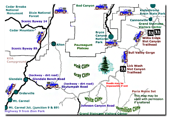
Map Grand Staircase National Monument Zion National Park Map Coral Pink Sand Dunes Map Zion National Park Lodging Cedar Breaks and Dixie National Forest Map Bryce Canyon and Red Canyon Map Grand Staircase-Escalante Map Zion National Park Map Coral Pink Sand Dunes Map Zion National Park Lodging Cedar Breaks and Dixie National Forest Map Grand Staircase-Escalante Map Bryce Canyon National Park Zion National Park Map Coral Pink Sand Dunes Map Zion National Park Lodging Cedar Breaks and Dixie National Forest Map Bryce Canyon and Red Canyon Map Grand Staircase-Escalante Map Zion National Park Map Coral Pink Sand Dunes Map Zion National Park Lodging Cedar Breaks and Dixie National Forest Map Grand Staircase-Escalante Map Bryce Canyon National Park Zion National Park Map Coral Pink Sand Dunes Map Zion National Park Lodging Cedar Breaks and Dixie National Forest Map Bryce Canyon and Red Canyon Map Grand Staircase-Escalante Map Zion National Park Map Coral Pink Sand Dunes Map Zion National Park Lodging Cedar Breaks and Dixie National Forest Map Bryce Canyon and Red Canyon Map Grand Staircase-Escalante Map Zion National Park Map Coral Pink Sand Dunes Map Zion National Park Lodging Cedar Breaks and Dixie National Forest Map Grand Staircase-Escalante Map Bryce Canyon National Park Zion National Park Map Coral Pink Sand Dunes Map Zion National Park Lodging Cedar Breaks and Dixie National Forest Map Bryce Canyon and Red Canyon Map Grand Staircase-Escalante Map Zion National Park Map Coral Pink Sand Dunes Map Zion National Park Lodging Cedar Breaks and Dixie National Forest Map Grand Staircase-Escalante Map Bryce Canyon National Park Zion National Park Map Coral Pink Sand Dunes Map Zion National Park Lodging Cedar Breaks and Dixie National Forest Map Bryce Canyon and Red Canyon Map Grand Staircase-Escalante Map Zion National Park Map Coral Pink Sand Dunes Map Zion National Park Lodging Cedar Breaks and Dixie National Forest Map Bryce Canyon and Red Canyon Map Grand Staircase-Escalante Map Zion National Park Map Coral Pink Sand Dunes Map Zion National Park Lodging Cedar Breaks and Dixie National Forest Map Bryce Canyon and Red Canyon Map Grand Staircase-Escalante Map

Share


Web Southwest Parks


Grand Staircase-Escalante National Monument - UTAH!


History of the Thunderbird

Best Western
East Zion Lodge

Reservations
1.888.848.6358

Zion Park Lodging

Zion National Park Lodging

East Zion Lodge
Vacation House
Group Lodging
East Zion Golf
East Zion RV Park
Vacation Packages
Family Reunion
Bus Tours
Business Retreat

Mileage from
Mt. Carmel Jct.

Zion National Park 12
Bryce Canyon 60
Grand Canyon 85
Cedar Breaks 45
Grand Staircase 9
Dixie Forest 22
Sand Dunes 11
Coyote Butte 57
Red Canyon 47
Tuweep 90

Stay in the heart of the parks, Mount Carmel Junction, and visit the treasures of the Southwest and Utah.

Site Map
Site Map II
Site Map III

Grand Staircase
National Monument
Visitor Centers
Roads in the Staircase
Landmarks
History
Fauna
Flora
Geology
For Kids

Skutumpah Road
Willis Creek

Lick Wash
Bull Valley Gorge

Cottonwood Road Hackberry Canyon
Yellow Rock
Cottonwood Canyon
Round Valley Draw

Wahweap
Wahweap Hoodoos
This is my new favorite quote:
"I don't know who Mary Cisneros is, but I mean zionnational-park.com
It's a better site than the NPS's anyway."
Written by the authors of the book: Favorite Hikes in and around Zion National Park
 
border

Zion History
Zion Landmarks
Zion Geology
Zion Geology II
Zion Geology III
Zion Fauna

Zion Rock Art

Disclaimer & Privacy Policy
All rights reserved © Copyright Zion National-Park  dot com
Do not use text, photos or maps without permission © Zion National-Park dot com
Contact the Author Mary Cisneros with any errors
Map of the Grand Staircase-Escalante National Monument Road Map to the Grand Staircase-Escalante National Monument Roads of the Grand Staircase-Escalante National Monument Visitor Centers: Grand Staircase-Escalante National Monument