|
|
 |
|||
|
Staircase | Lodging | Camping | Maps | Coyote Buttes | Weather | Hiking | Backpack | Hwy 89 | Vacation | Pictures |
||||

Camping: Grand Staircase-Escalante National Monument, UtahDispersed camping is permitted in some areas, but a (free) backcountry permit is required. Leave no trace rules are required. There are only two developed campgrounds inside the boundaries of the Staircase, but they are in the Escalante region. The White House campground located between Kanab and Page has 5 sites. This is also the campground for the Paria Canyon Wilderness.
Primitive Camping in the Grand Staircase - Back country permits are required for all overnight camping or backpacking in Grand Staircase-Escalante National Monument. Permits are free. Contact a Grand Staircase Visitor Center for permits: Grand Staircase-Escalante National Monument Kanab Visitor Center Kanab Field Office Paria Contact Station
The theme at the visitor center at Big Water is paleontology of the monument. The shape of the building is derived from an ammonite and the rockwork mimics the layers found in the sandstone cliffs nearby. Cannonville Grand Staircase-Escalante Visitor Center. Cannonville's theme is on the early settler history. The building and the fence around it is a design from a vernacular stone house. The building and the fence around it is a design from a vernacular stone house. The theme at the visitor center at Big Water is paleontology of the monument. The shape of the building is derived from an ammonite and the rockwork mimics the layers found in the sandstone cliffs nearby. The Kanab visitor center has a focus on "traces in time" which includes both geology and archeology. "Escalante" was the name given by John Wesley Powell in 1872. Escalante was the name of a Spanish missionary and the river is a tributary of the Colorado River.
East Zion Riverside RV Park - 35' or less trailers. No pull through. A cozy RV park with shade trees and free dump. Located 6 miles from the Glendale entrance to the Grand Staircase, on the rim of the Virgin River. Seasonal heated pool, hot tub, on-site lodging, dining and massage service. Relax in the Sports Lounge and take a guided jeep tour to the incredible Red Cave or ancient Indian pictographs. Mount Carmel Junction, Utah Grand Staircase-Escalante Lodging Ponderosa Grove Campground (BLM) Kodachrome Basin State Park - 9 miles south of Cannonville. There is a GSENM Visitor Center there. Red Canyon - Dixie National Forest Coral Pink Sand Dunes - 11 miles from Mount Carmel Junction. 1.800.322.3770
Grand Staircase-Escalante Roads - Pristine and remote describes the roadways within the Grand Staircase Escalante National Monument. Highway 89 defines the southern border and Highway 12 accesses the northern side. In addition to Highways 12 and 89, there are 959 miles of open road in the Grand Staircase. Glendale, Utah, located on Highway 89, northeast of Zion National Park, connects the east side of Zion to Bryce Canyon via the Glendale Bench Road and the scenic backway, Skutumpah Road. To the north, Highway 12 connects Tropic and Boulder, Utah. At the southern end of the monument, roads connect Kanab, Utah and Page, Arizona. The most popular roads in the Grand Staircase are probably Skutumpah Road accessed either by the Glendale Bench Road, near the east entrance to Zion, or the Johnson Canyon Road near Kanab, both leading to Kodachrome Basin near Bryce Canyon. All interior roads except for portions of the Burr Trail and Johnson Canyon Road are unpaved and may be impassible if wet. 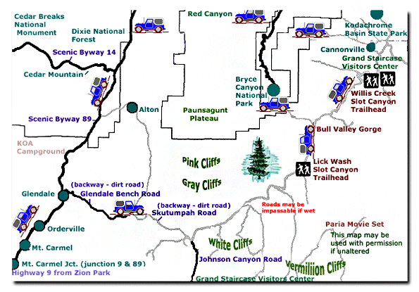
Grand Staircase-Escalante National Monument - UTAH!History of the Thunderbird |
East Zion Lodge Mileage from Stay in the heart of the parks, Mount Carmel Junction, and visit the treasures of the Southwest and Utah. Grand Staircase Skutumpah Road Cottonwood Road Hackberry Canyon Wahweap Hoodoos |
||||||||||||
|
This is my new favorite quote:
"I don't know who Mary Cisneros is, but I mean zionnational-park.com It's a better site than the NPS's anyway." Written by the authors of the book: Favorite Hikes in and around Zion National Park |
|||||||||||||

 Developed campgrounds at the perimeter of the monument along Highways 12 and 89


|
Zion History |
|---|
All rights reserved © Copyright Zion National-Park dot com
Do not use text, photos or maps without permission © Zion National-Park dot com
Contact the Author Mary Cisneros with any errors