|
|
 |
|||
|
Staircase | Lodging | Camping | Maps | Coyote Buttes | Weather | Hiking | Backpack | Hwy 89 | Vacation | Pictures |
||||

Cottonwood Canyon: Grand Staircase-Escalante National Monument
Cottonwood Canyon Trailhead - From Mount Carmel Junction, on the east side of Zion Park, drive through Kanab then 32 miles on Highway 89. Look for the turn-off and BLM sign, between mile markers 17 and 18, indicating the entrance into Cottonwood Canyon. The Paria Contact Station is 2.2 miles east of the turnoff. The roads in the GSENM are remote and most of them are dirt and clay. Cottonwood Road, like most of the GSENM roads, is impassible when wet and impossible if there is snow or melting snow present. Always bring a spare tire in the dirt wilderness roads and carry lots of water. Be prepared for emergencies. A high clearance 4WD is nice on this road, but it's not required in normal driving conditions. To find Cottonwood Narrows or Cottonwood Creek, stay on the main road, ignoring the seldom used side roads. Park 25.5 miles from the turnoff from Highway 89 at the small pullout in a hollow between two passes. Identify the hollow with large multicolored red and white and red rocks on the east side of the road near the parking area. Locate the trail on the west side of the road and climb down a short 8' scrambling section into the wash. Travel can be done to the right (up canyon) into a .25 mile section of narrows and then back down canyon.
The slot turns at the towering blind arch and leads through one of the oddest structures in the Grand Staircase, the cockscomb. It is hard to see at such a close view, but after returning to your car take note. The trail will detour to the left to avoid the large boulders before it widens and ends at the trail-box. Be sure to watch for the trail of use that leaves the wash and goes to the road. Sign the trail register and hike up to the road. It is about a mile back to your vehicle.
GPS coordinates are only references and may or may not be accurate. Do not rely on GPS coordinates as the sole method of navigation. Always have an accurate, detailed map at hand and have the proper map reading and navigation skills before setting out on any hike. Many of the hikes listed in this guide travel into canyons where a GPS has limited capabilities. Always check your position with a detailed map before dropping into a canyon. This slot canyon is located along Cottonwood Road in the GSENM. It will take about two hours to explore the wash and return back to your vehicle via the road.
Grand Staircase-Escalante Roads - Pristine and remote describes the roadways within the Grand Staircase Escalante National Monument. Highway 89 defines the southern border and Highway 12 accesses the northern side. In addition to Highways 12 and 89, there are 959 miles of open road in the Grand Staircase. Glendale, Utah, located on Highway 89, northeast of Zion National Park, connects the east side of Zion to Bryce Canyon via the Glendale Bench Road and the scenic backway, Skutumpah Road. To the north, Highway 12 connects Tropic and Boulder, Utah. At the southern end of the monument, roads connect Kanab, Utah and Page, Arizona. The most popular roads in the Grand Staircase are probably Skutumpah Road accessed either by the Glendale Bench Road, near the east entrance to Zion, or the Johnson Canyon Road near Kanab, both leading to Kodachrome Basin near Bryce Canyon. All interior roads except for portions of the Burr Trail and Johnson Canyon Road are unpaved and may be impassible if wet. 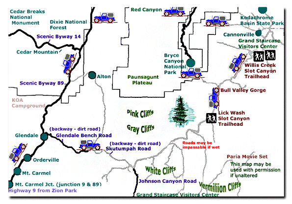
Grand Staircase-Escalante National Monument - UTAH!History of the Thunderbird |
East Zion Lodge Mileage from Stay in the heart of the parks, Mount Carmel Junction, and visit the treasures of the Southwest and Utah. Grand Staircase Skutumpah Road Cottonwood Road Hackberry Canyon Wahweap Hoodoos |
||||||||||||
|
This is my new favorite quote:
"I don't know who Mary Cisneros is, but I mean zionnational-park.com It's a better site than the NPS's anyway." Written by the authors of the book: Favorite Hikes in and around Zion National Park |
|||||||||||||
 Cottonwood Canyon at a Glance

 Parking


|
Zion History |
|---|
All rights reserved © Copyright Zion National-Park dot com
Do not use text, photos or maps without permission © Zion National-Park dot com
Contact the Author Mary Cisneros with any errors