|
|
 |
|||
|
Staircase | Lodging | Camping | Maps | Coyote Buttes | Weather | Hiking | Backpack | Hwy 89 | Vacation | Pictures |
||||

Bull Valley Gorge to Sheep Creek to Willis CreekGrand Staircase-Escalante National Monument, UtahBull Valley Gorge is a dimly lit canyon cut through the rugged and wild land of the Grand Staircase-Escalante National Monument. Canyon walls spread allowing rays of sun to bathe the sandy ground as you leave the tight confines of the slot. The next leg of the journey takes you through Sheep Creek where the sound of flowing water eventually lures hikers toward an eerie, yellow glowing canyon. This is Willis Creek, a delightfully bright assemblage of sculpted rock embracing a gentle cobblestone stream that meanders through the serene passage. For those of you who want an easier hike, simply do this route backwards and go as far as you are comfortable with, then turn around and go back to the start at the trailhead for Willis Creek.
Getting to Skutumpah Road - If you are driving from St. George, you can go through Zion National Park and then take Highway 89 north to Glendale. Turning right on 300 N. (Bench Road) and follow the graded dirt road to where it intersects with Johnson Canyon and Skutumpah Roads. There is an information kiosk at the junction. The other option is to take Highway 389 out of Hurricane to Fredonia, then continue east on Highway 89 toward Page, Arizona. Locate Johnson Canyon Road, which will be on the left side of the highway about 8.5 miles east of Kanab. Turn and follow the road until the paved road ends where it intersects with Skutumpah Road. Skutumpah Road to Bull Valley Gorge - Take Skutumpah Road at the intersection and continue 15 miles, passing Lick Wash on the right, then drive another 10 miles to Bull Valley Gorge. There are no signs, but look for the narrow wooden bridge that stretches over the gorge. If you continue to drive on Skutumpah Road another 1.8 miles you will be at Willis Creek where your hike will end. Flash floods dramatically rearrange obstacles in this gorge, so be aware that deep pools of cold water and waterfalls or dry falls may be present. Wear sticky soled shoes and bring a 50' section of rope or 1" tubular webbing. Trailhead - Park by the bridge then hike up canyon staying on the right side of the chasm to locate the registration box. Stay along the edge until you find a shallow place to climb down into the canyon. Don't drop in too soon or you will miss a spectacular section of narrows. Most of the down climbs should be fairly easy, but it's always safer to have a climber or experienced canyoneer in the group. Bull Valley Gorge - The gray striated rock of this dimly lit earthen crevice are tall, fluted and spectacular. If you are lucky there might be a stream of water forming puddles as it moves down the wash. Look up to where the 100 foot walls open to about 30 feet wide to see a relic, a 1954 pickup truck, wedged into the slot making up a portion of the bridge. Not far past the bridge is a tributary on the right filled with trees and another on the left. At about the 2 mile mark there are large juniper and fir trees growing on the sides of the canyon and soon two more side washes come into the gorge. The walls widen to about 400 yards and the rocky bottom gives way to clay and sand once you have traveled about 3 miles. Sheep Creek - At 3.5 miles look for a large fin of rock up high and on the left side of the canyon, and notice the arch or small window. The gorge will bend around this large buttress making a dog leg turn to the east (left) and steer toward the confluence with the north-south running wash of Sheep Creek. A narrow slot will come into the gorge at about the 6 mile mark, where you will need to turn left and travel north into Sheep Creek. Follow the fairly level terrain for about 4 miles. It's hot in this section and there is little to no shade, but about midway through, a gentle flow of water trickles through the sandy wash. Willis Creek - At 10 miles into the hike there should be a wilderness sign where another canyon intersects with Sheep Creek from the west. Follow the stream of water that has been present through Sheep Creek by turning left and you will begin the Willis Creek narrows. Horses and cows visit there, so don't drink without treating the water first. You will pass by Averett Creek, on the right, 1.3 miles from the Sheep Creek-Willis Creek confluence. The constricted walls of Willis Creek capture the afternoon sun where sunlit rock puts on a grand show for photographers in the 2.5 mile long passage. There are a couple of fun little waterfalls near the end of the trail that can be hiked around if needed. Skutumpah back to Bull Valley Gorge - Once at Skutumpah Road, turn left and walk 2 miles back to the Bull Valley Gorge trailhead and your vehicle. Initially the road is a gentle ascent, but then levels out once on top of the plateau. GPS Coordinates WGS84 Datum - GPS coordinates are only references and may or may not be accurate. Do not rely on GPS coordinates as the sole method of navigation. Always have an accurate, detailed map at hand and have the proper map reading and navigation skills before setting out on any hike. Many of the hikes listed in this guide travel into canyons where a GPS has limited capabilities. Always check your position with a detailed map before dropping into a canyon.
How Bull Valley Gorge got its name - The odd name, Bull Valley Gorge, is said to be given when the area was used to raise cattle and bulls. The different types of animals were kept apart by the gorge. The gorge drains southeast into the Paria River. Averett Canyon - Residents of Glendale, one of the entrances into the Grand Staircase, were victims of Indian raiders in 1866. Elijah Averett was killed while crossing Averett Canyon during his hunt for the raiders.
Grand Staircase-Escalante Roads - Pristine and remote describes the roadways within the Grand Staircase Escalante National Monument. Highway 89 defines the southern border and Highway 12 accesses the northern side. In addition to Highways 12 and 89, there are 959 miles of open road in the Grand Staircase. Glendale, Utah, located on Highway 89, northeast of Zion National Park, connects the east side of Zion to Bryce Canyon via the Glendale Bench Road and the scenic backway, Skutumpah Road. To the north, Highway 12 connects Tropic and Boulder, Utah. At the southern end of the monument, roads connect Kanab, Utah and Page, Arizona. The most popular roads in the Grand Staircase are probably Skutumpah Road accessed either by the Glendale Bench Road, near the east entrance to Zion, or the Johnson Canyon Road near Kanab, both leading to Kodachrome Basin near Bryce Canyon. All interior roads except for portions of the Burr Trail and Johnson Canyon Road are unpaved and may be impassible if wet. Beta: Coordinates and other trail and canyoneering information by Zion Park search and rescue veteran team member Bo Beck and zionnational-park.com author, Mary Cisneros. Suggested Gear: Rope, webbing, harness and rappelling device. A sturdy pair of shoes are recommend for canyoneering in Zion . Quality shoes will help grip the rocks and prevent injury. Experienced Zion hikers and canyoneers like the Sportiva Exum Ridge. This shoe is great for hiking, bouldering and canyoneering. 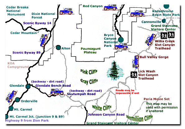
Grand Staircase-Escalante National Monument - UTAH!History of the Thunderbird |
East Zion Lodge Mileage from Stay in the heart of the parks, Mount Carmel Junction, and visit the treasures of the Southwest and Utah. Grand Staircase Skutumpah Road Cottonwood Road Hackberry Canyon Wahweap Hoodoos |
||||||||||||||
|
This is my new favorite quote:
"I don't know who Mary Cisneros is, but I mean zionnational-park.com It's a better site than the NPS's anyway." Written by the authors of the book: Favorite Hikes in and around Zion National Park |
|||||||||||||||
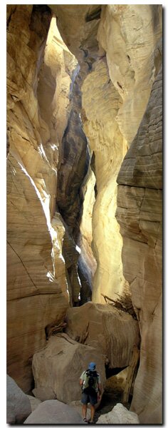 Photo Album:


|
Zion History |
|---|
All rights reserved © Copyright Zion National-Park dot com
Do not use text, photos or maps without permission © Zion National-Park dot com
Contact the Author Mary Cisneros with any errors