|
|

|
|||
|
Zion National Park Lodging Zion Info Vacation Weather Photos Hike Slot Canyons Backpack Camping |
||||

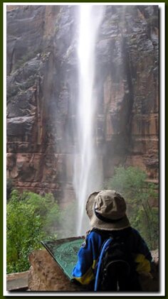
Best Quickies in Zion National ParkThree Patriarchs - Enjoy this short uphill walk to a viewpoint of the Three Patriarchs: Abraham, Isaac, and Jacob, which is mostly hidden behind Mount Moroni. In the center of the Patriarchs, is a favorite big wall climb and a nesting place for the Peregrine Falcon. Also seen from the vantage area is the Streaked Wall and Sentinel to the south, the Spearhead and Angels Landing to the north and Mountain of the Sun and Twin Brothers are seen to the east. Big Bend - The shuttle will stop at Big Bend and unload. This is a great place to get off the shuttle and take some pictures. If you are in your own car, the Big Bend stop is about mid-way on the Zion Canyon road. Often during the year climbers can be seen making their way up the giant monolith from this stop. Angels Landing is a spectacular big wall climb as well as an impressive hiking trail. Horseback Riding - The Sand Bench Trail offers a summer ride along the Sand Bench trail. Weeping Rock - This short, half-mile, round-trip trail is moderately steep and well traveled. At the top of the trail be prepared for slippery moss and water dripping where rock steps lead to the large alcove at the end of the trail. Continuous water weeps out of a spring-seep alcove feeding plant life that has imbedded its roots into the sandstone. The view from the cubby hole into Zion Canyon is outstanding as it frames some of the most magnificent monoliths in the park. Look for Angels Landing on the right; to the left is Lady Mountain and on the far left is the Great White Throne. The entire 30 minute hike is exceptionally enjoyable. Emerald Pools Hike - The Emerald Pools Trail leads to a trio of unique pools and falls. The lower pool is an easy hike that is wheelchair accessible. The trail becomes a moderate hike once travel continues past the lower pool, although the Middle Pools are just a quick, yet steep jaunt from the lower section. The hike to the Upper Emerald Pool is fairly strenuous. There are three ways to enter or exit this trail, so unlike most of Zion's classics there is no need to back-track the way you came. The best way to hike this is to get off the shuttle at the Zion Lodge shuttle stop and take the lower Emerald Pool Trail. This trail is an easy stroll and the scenery is exceptional. Once at the lower pool, keep following the path as it gets rocky and step. Signs will show the way to the two middle pools. Be sure that you do get to see both of them. It's easy to get side tracked up there and miss part of the whole trail system. To return, choose either the Middle Emerald Pool Trail that ends at the Zion Lodge area or the Kayenta Trail that ends at the Grotto picnic area. Either of these trails has nice scenery, but the Kayenta Trail offers the best return views of the Virgin River. The shuttle will pick you up at either trailhead. Lower Pool - Easy Walk, paved path: .6 miles one way. Accessible. Water drips down from the Middle Pools into the Lower Pool.
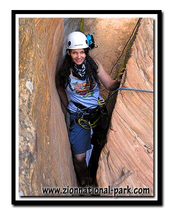
Riverside Walk Hike - Historically called Gateway to the Narrows, the Riverside Walk in many ways is more appropriate. The trailhead is located at the farthest end of Zion Canyon. This 2-mile trail is the entrance to the Zion Narrows and is a graded dirt path with little change in elevation. Wheelchairs and strollers can be taken along the path, but sand does build up on the cement in places making it difficult to push them. The ease and beauty of this hike is the reason for its popularity. The trail follows the North Fork of the Virgin River along a riparian environment. There are some fun microenvironments to explore including small desert swamps and hanging gardens. Fat squirrels will beg for food along the path, please be kind and do not feed them. Allow 1.5 hours for this walk and a bit more time if you want to play in the water at the end. Mid-Afternoon in Zion Canyon Overlook Trail - East of the Zion-Mt. Carmel Tunnel is the Canyon Overlook Trail. This is a must-do hike. Plan for an easy one-mile, round-trip, ending with a great view of lower Zion Canyon and Pine Creek Canyon. You will be walking alongside canyoneering route, Pine Creek. Allow one hour for this hike. Getting Ready for Day two in Bryce Canyon - Stop in Mount Carmel Junction, located on the east side of Zion National Park and take a break for dinner and stay the night. From Mt. Carmel Junction it is 60 highway miles to Bryce Canyon. You might even have some time to play a round of golf on the unique and inexpensive course in Mt. Carmel Jct. The Best of Zion National Park Zion Narrows - It seems that Zion National Park ends at the Temple of Sinawava at the termination of the Riverside Walk, but in fact, the adventure is just beginning when you step into the water. The Zion Narrows is a slot canyon extraordinaire and is, without a doubt, the most famous hike in Utah and the most notorious slot canyon anywhere in the world. Wear sturdy water shoes like La Sportiva or 5'10 canyoneers and step into the water and experience the famous Narrows. Travel up canyon as far as you want, then turn around and come out the way you came. Orderville Canyon is an enjoyable spur off the Narrows.Angels Landing Trail - Angels Landing and the Zion Narrows are considered to be the very best in Zion National Park, if not the best hikes in the entire National Park system. More Hiking in Zion - If you have done the classics, check out the hiking guide by Bo Beck and Mary Cisneros where you will be sure to find routes in and around the park that you have never done. Backpacking in Zion - Choose to backpack for two spectacular days through the Zion Narrows or along the incredible East Rim Trail or West Rim Trail.
Zion National Park, UtahHistory of the Thunderbird |
East Zion Lodge Mileage from Stay in the heart of the parks, Mount Carmel Junction, and visit the treasures of the Southwest and Utah. Site Map Zion Hiking
|
|||||||||||||||


|
Zion History |
|---|
All rights reserved © Copyright Zion National-Park.com
Do not use text, photos or maps without permission from Zion National-Park.com