|
|

|
|||
|
Zion National Park Lodging Zion Info Vacation Weather Photos Hike Slot Canyons Backpack Camping |
||||

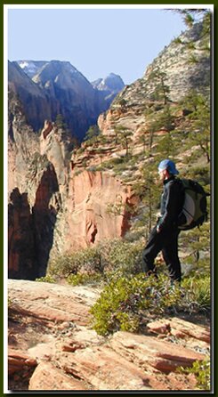
Backpacking in Southern UtahBackpacking opportunities abound in Southern Utah. Zion National Park, Bryce Canyon National Park, and the vast Grand Staircase-Escalante National Monument dish up an abundance of backcountry trails. 
North Rim Grand Canyon Backpacking - The Ken Patrick Trail is a 10 mile hike that does not go below the rim. This trail runs through the forest along the rim from Point Imperial and can be combined with the Uncle Jim Trail for a nice backpack. The North Kaibab Trail is a 14.2 mile, one way, strenuous hike. This is the only maintained North Rim trail leading to the Colorado River. Camping at Cottonwood Campground, then visiting Ribbon Falls the next day, is an enjoyable backpack. The Rim-to-Rim Trail, down the North Kaibab Trail to the river and up Bright Angel Trail to the South Rim is a popular destination backpack. Some of the more remote backpacks include Thunder River and South Canyon.
Bryce Canyon Backpacking - The 23 mile round-trip, Under the Rim Trail, in Bryce Canyon is a moderately strenuous and remote backpack. The backpack begins at Bryce Point and goes through the forested areas, below the rim, to Rainbow Point. Cedar Breaks Backpacking GSENM Backpacking - The Grand Staircase-Escalante National Monument is not lacking in backpacking adventures. Bull Valley Gorge is a long hike through a deep gorge. Combine this slot canyon with Sheep Creek and Willis Creek and it becomes a magnificent two day adventure.The trailhead is found along the Skutumpah Road. Backpacking in Southern Utah
Zion National Park, UtahHistory of the Thunderbird |
East Zion Lodge Mileage from Stay in the heart of the parks, Mount Carmel Junction, and visit the treasures of the Southwest and Utah. Site Map Zion Hiking |
|||||||||||||
|
This is my new favorite quote:
"I don't know who Mary Cisneros is, but I mean zionnational-park.com It's a better site than the NPS's anyway." Written by the authors of the book: Favorite Hikes in and around Zion National Park |
||||||||||||||


|
Zion History |
|---|
All rights reserved © Copyright Zion National-Park dot com
Do not use text, photos or maps without permission © Zion National-Park dot com
Contact the Author Mary Cisneros with any errors