border

Parunuweap Canyon

This route is a hike only, avoiding Fat Man' Misery, a demanding technical slot canyon, allowing hikers to access Parunuweap Canyon.

Options:

1. The Hike which avoids the technical slot canyon

2. Loop from Zion and back

3. Zion to an exit at Elephant Butte

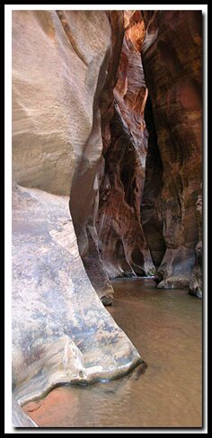
One of the most magnificent slot canyon experiences in southern Utah begins at Checkerboard Mesa in Zion National Park and continues into BLM land and through sections of the East Fork of the Virgin River, dubbed Parunuweap by John Wesley Powell. Along this hike you can view the memorial plaque dedicated to Powell's historic journey and envision the difficulties and sheer excitement that was confronted during his trip through this magical wilderness. Sheer canyon walls envelope the meandering, yet sometimes - violent flow of the East Fork of the Virgin River, as it makes its way westward to join the Virgin River in Springdale. With some effort it is possible to go downstream and look at Labyrinth Falls from above and wonder how a century ago explorers conceived of continuing. A short stroll upstream allows a glimpse of the warm desert oasis and spring fed, lush pool known as Sulfur Spring, located just outside of the popular technical canyon route of Fat Man's Misery. Along the way revel in the narrow passage way cut in the Navajo sandstone that rivals the famous Zion Narrows.

Zion Book: Favorite Hikes in and around Zion National ParkAt a Glance
Photo Album: Parunuweap Pictures
Trail Maps:
Map 1 Map 2
Day Hike:
Yes, but would be a nice backpack
Distance: 10-miles round trip.
Average Hiking Time:
12 hours
Equipment: All hikers will need plenty of water or water purification or filtration method, topo maps (Springdale East and the Barracks USGS 7.5'), dry bag, sun protection, sticky rubber hiking/water shoes and energy food. Side trip to Labyrinth Falls requires a 50' rope, webbing, harness, and a rappel device.
Difficulty: There is strenuous hiking in sand and over slickrock as well as river hiking. There is one tenuous "slab" down-climb and traverse during the descent to the river. This hike is not for the meager and requires good physical stamina, conditioning and route finding skills. Poison Ivy is present in many places along the river.
Permits: No permit is required. Check the weather report before hiking this route. Do not hike if it looks like rain at or near the trailhead or if it looks like rain in the Alton area, which is near the head of the East Fork of the Virgin River.
Trailhead: This depends on where parking is available. If the small pullout just southwest of the main Checkerboard Mesa viewpoint is full then park at the Checkerboard Mesa parking lot.
Trailend: Same as trailhead.
Trail Access: The parking area can be accessed year-round via the Zion-Mt. Carmel Highway. Cold river temperatures, heavy current and frozen patches on the "trail" can deter most hikers in the winter months.
Off the Beaten Path: Yes
Best Season: This hike is more comfortable when the water temperatures are warm as in mid-June to mid-September. However the approach and exit for this hike are in full sun and can be brutal in the summer. It helps to do the approach in the early part of the day and the exit in the later part of the day. Winter months and snow deter most hikers.
Trailhead: Begin the hike by parking your vehicle at either the Checkerboard Mesa viewpoint parking area, just north of Checkerboard Mesa, on the east side of Zion National Park, or locate the pullout a half mile to the west on the Zion-Mt. Carmel Highway. The later parking area cuts off one mile of hiking to the round-trip.

Map: Zion National Park Coral Pink Sand Dunes Map Grand Staircase-Escalante Map Bryce Canyon National Park Grand Canyon National Park, Arizona - North Rim Map Red Canyon, Dixie National Forest, Utah Lodging: Zion National Park Cedar Breks National Monument, Utah Dixie National Forest: Cedar Mountain Zion National Park State Road 9 - Zion-Mt. Carmel Highway Southern Utah Scenic Byways Zion National Park Map Coral Pink Sand Dunes Map Zion National Park Lodging Cedar Breaks and Dixie National Forest Map Bryce Canyon and Red Canyon Map Grand Staircase-Escalante Map Zion National Park Map Coral Pink Sand Dunes Map Zion National Park Lodging Cedar Breaks and Dixie National Forest Map Grand Staircase-Escalante Map Bryce Canyon National Park Zion National Park Map Coral Pink Sand Dunes Map Zion National Park Lodging Cedar Breaks and Dixie National Forest Map Bryce Canyon and Red Canyon Map Grand Staircase-Escalante Map Zion National Park Map Coral Pink Sand Dunes Map Zion National Park Lodging Cedar Breaks and Dixie National Forest Map Grand Staircase-Escalante Map Bryce Canyon National Park Zion National Park Map Coral Pink Sand Dunes Map Zion National Park Lodging Cedar Breaks and Dixie National Forest Map Bryce Canyon and Red Canyon Map Grand Staircase-Escalante Map Zion National Park Map Coral Pink Sand Dunes Map Zion National Park Lodging Cedar Breaks and Dixie National Forest Map Bryce Canyon and Red Canyon Map Grand Staircase-Escalante Map Zion National Park Map Coral Pink Sand Dunes Map Zion National Park Lodging Cedar Breaks and Dixie National Forest Map Grand Staircase-Escalante Map Bryce Canyon National Park Zion National Park Map Coral Pink Sand Dunes Map Zion National Park Lodging Cedar Breaks and Dixie National Forest Map Bryce Canyon and Red Canyon Map Grand Staircase-Escalante Map Zion National Park Map Coral Pink Sand Dunes Map Zion National Park Lodging Cedar Breaks and Dixie National Forest Map Grand Staircase-Escalante Map Bryce Canyon National Park Zion National Park Map Coral Pink Sand Dunes Map Zion National Park Lodging Cedar Breaks and Dixie National Forest Map Bryce Canyon and Red Canyon Map Grand Staircase-Escalante Map Zion National Park Map Coral Pink Sand Dunes Map Zion National Park Lodging Cedar Breaks and Dixie National Forest Map Bryce Canyon and Red Canyon Map Grand Staircase-Escalante Map Zion National Park Map Coral Pink Sand Dunes Map Zion National Park Lodging Cedar Breaks and Dixie National Forest Map Bryce Canyon and Red Canyon Map Grand Staircase-Escalante Map Coral Pink Sand Dunes Map Grand Staircase-Escalante Map Bryce Canyon National Park Grand Canyon National Park, Arizona - North Rim Map Red Canyon, Dixie National Forest, Utah Lodging: Zion National Park Zion National Park Cedar Breks National Monument, Utah Dixie National Forest: Cedar Mountain Zion National Park Map Coral Pink Sand Dunes Map Zion National Park Lodging Cedar Breaks and Dixie National Forest Map Bryce Canyon and Red Canyon Map Grand Staircase-Escalante Map Zion National Park Map Coral Pink Sand Dunes Map Zion National Park Lodging Cedar Breaks and Dixie National Forest Map Grand Staircase-Escalante Map Bryce Canyon National Park Zion National Park Map Coral Pink Sand Dunes Map Zion National Park Lodging Cedar Breaks and Dixie National Forest Map Bryce Canyon and Red Canyon Map Grand Staircase-Escalante Map Zion National Park Map Coral Pink Sand Dunes Map Zion National Park Lodging Cedar Breaks and Dixie National Forest Map Bryce Canyon and Red Canyon Map Grand Staircase-Escalante Map Coral Pink Sand Dunes Map Grand Staircase-Escalante Map Bryce Canyon National Park Grand Canyon National Park, Arizona - North Rim Map Red Canyon, Dixie National Forest, Utah Lodging: Zion National Park Zion National Park Cedar Breks National Monument, Utah Dixie National Forest: Cedar Mountain Zion National Park Map Coral Pink Sand Dunes Map Zion National Park Lodging Cedar Breaks and Dixie National Forest Map Bryce Canyon and Red Canyon Map Grand Staircase-Escalante Map Zion National Park Map Coral Pink Sand Dunes Map Zion National Park Lodging Cedar Breaks and Dixie National Forest Map Grand Staircase-Escalante Map Bryce Canyon National Park Zion National Park Map Coral Pink Sand Dunes Map Zion National Park Lodging Cedar Breaks and Dixie National Forest Map Bryce Canyon and Red Canyon Map Grand Staircase-Escalante Map Zion National Park Map Coral Pink Sand Dunes Map Zion National Park Lodging Cedar Breaks and Dixie National Forest Map Bryce Canyon and Red Canyon Map Grand Staircase-Escalante Map Zion National Park Map Coral Pink Sand Dunes Map Zion National Park Lodging Cedar Breaks and Dixie National Forest Map Bryce Canyon and Red Canyon Map Grand Staircase-Escalante Map Coral Pink Sand Dunes Map Grand Staircase-Escalante Map Bryce Canyon National Park Grand Canyon National Park, Arizona - North Rim Map Red Canyon, Dixie National Forest, Utah Lodging: Zion National Park Zion National Park Cedar Breks National Monument, Utah Dixie National Forest: Cedar Mountain Zion National Park Map Coral Pink Sand Dunes Map Zion National Park Lodging Cedar Breaks and Dixie National Forest Map Bryce Canyon and Red Canyon Map Grand Staircase-Escalante Map Zion National Park Map Coral Pink Sand Dunes Map Zion National Park Lodging Cedar Breaks and Dixie National Forest Map Grand Staircase-Escalante Map Bryce Canyon National Park Zion National Park Map Coral Pink Sand Dunes Map Zion National Park Lodging Cedar Breaks and Dixie National Forest Map Bryce Canyon and Red Canyon Map Grand Staircase-Escalante Map Zion National Park Map Coral Pink Sand Dunes Map Zion National Park Lodging Cedar Breaks and Dixie National Forest Map Bryce Canyon and Red Canyon Map Grand Staircase-Escalante Map Coral Pink Sand Dunes Map Grand Staircase-Escalante Map Bryce Canyon National Park Grand Canyon National Park, Arizona - North Rim Map Red Canyon, Dixie National Forest, Utah Lodging: Zion National Park Zion National Park Cedar Breks National Monument, Utah Dixie National Forest: Cedar Mountain Zion National Park Map Coral Pink Sand Dunes Map Zion National Park Lodging Cedar Breaks and Dixie National Forest Map Bryce Canyon and Red Canyon Map Grand Staircase-Escalante Map Zion National Park Map Coral Pink Sand Dunes Map Zion National Park Lodging Cedar Breaks and Dixie National Forest Map Grand Staircase-Escalante Map Bryce Canyon National Park Zion National Park Map Coral Pink Sand Dunes Map Zion National Park Lodging Cedar Breaks and Dixie National Forest Map Bryce Canyon and Red Canyon Map Grand Staircase-Escalante Map Zion National Park Map Coral Pink Sand Dunes Map Zion National Park Lodging Cedar Breaks and Dixie National Forest Map Bryce Canyon and Red Canyon Map Grand Staircase-Escalante Map Zion National Park Map Coral Pink Sand Dunes Map Zion National Park Lodging Cedar Breaks and Dixie National Forest Map Bryce Canyon and Red Canyon Map Grand Staircase-Escalante Map Zion National Park Map Coral Pink Sand Dunes Map Zion National Park Lodging Cedar Breaks and Dixie National Forest Map Bryce Canyon and Red Canyon Map Grand Staircase-Escalante Map Coral Pink Sand Dunes Map Grand Staircase-Escalante Map Bryce Canyon National Park Grand Canyon National Park, Arizona - North Rim Map Red Canyon, Dixie National Forest, Utah Lodging: Zion National Park Zion National Park Cedar Breks National Monument, Utah Dixie National Forest: Cedar Mountain Zion National Park Map Coral Pink Sand Dunes Map Zion National Park Lodging Cedar Breaks and Dixie National Forest Map Bryce Canyon and Red Canyon Map Grand Staircase-Escalante Map Zion National Park Map Coral Pink Sand Dunes Map Zion National Park Lodging Cedar Breaks and Dixie National Forest Map Grand Staircase-Escalante Map Bryce Canyon National Park Zion National Park Map Coral Pink Sand Dunes Map Zion National Park Lodging Cedar Breaks and Dixie National Forest Map Bryce Canyon and Red Canyon Map Grand Staircase-Escalante Map Zion National Park Map Coral Pink Sand Dunes Map Zion National Park Lodging Cedar Breaks and Dixie National Forest Map Bryce Canyon and Red Canyon Map Grand Staircase-Escalante Map Coral Pink Sand Dunes Map Grand Staircase-Escalante Map Bryce Canyon National Park Grand Canyon National Park, Arizona - North Rim Map Red Canyon, Dixie National Forest, Utah Lodging: Zion National Park Zion National Park Cedar Breks National Monument, Utah Dixie National Forest: Cedar Mountain Zion National Park Map Coral Pink Sand Dunes Map Zion National Park Lodging Cedar Breaks and Dixie National Forest Map Bryce Canyon and Red Canyon Map Grand Staircase-Escalante Map Zion National Park Map Coral Pink Sand Dunes Map Zion National Park Lodging Cedar Breaks and Dixie National Forest Map Grand Staircase-Escalante Map Bryce Canyon National Park Zion National Park Map Coral Pink Sand Dunes Map Zion National Park Lodging Cedar Breaks and Dixie National Forest Map Bryce Canyon and Red Canyon Map Grand Staircase-Escalante Map Zion National Park Map Coral Pink Sand Dunes Map Zion National Park Lodging Cedar Breaks and Dixie National Forest Map Bryce Canyon and Red Canyon Map Grand Staircase-Escalante Map Zion National Park Map Coral Pink Sand Dunes Map Zion National Park Lodging Cedar Breaks and Dixie National Forest Map Bryce Canyon and Red Canyon Map Grand Staircase-Escalante Map Coral Pink Sand Dunes Map Grand Staircase-Escalante Map Bryce Canyon National Park Grand Canyon National Park, Arizona - North Rim Map Red Canyon, Dixie National Forest, Utah Lodging: Zion National Park Zion National Park Cedar Breks National Monument, Utah Dixie National Forest: Cedar Mountain Zion National Park Map Coral Pink Sand Dunes Map Zion National Park Lodging Cedar Breaks and Dixie National Forest Map Bryce Canyon and Red Canyon Map Grand Staircase-Escalante Map Zion National Park Map Coral Pink Sand Dunes Map Zion National Park Lodging Cedar Breaks and Dixie National Forest Map Grand Staircase-Escalante Map Bryce Canyon National Park Zion National Park Map Coral Pink Sand Dunes Map Zion National Park Lodging Cedar Breaks and Dixie National Forest Map Bryce Canyon and Red Canyon Map Grand Staircase-Escalante Map Zion National Park Map Coral Pink Sand Dunes Map Zion National Park Lodging Cedar Breaks and Dixie National Forest Map Bryce Canyon and Red Canyon Map Grand Staircase-Escalante Map Coral Pink Sand Dunes Map Grand Staircase-Escalante Map Bryce Canyon National Park Grand Canyon National Park, Arizona - North Rim Map Red Canyon, Dixie National Forest, Utah Lodging: Zion National Park Zion National Park Cedar Breks National Monument, Utah Dixie National Forest: Cedar Mountain Zion National Park Map Coral Pink Sand Dunes Map Zion National Park Lodging Cedar Breaks and Dixie National Forest Map Bryce Canyon and Red Canyon Map Grand Staircase-Escalante Map Zion National Park Map Coral Pink Sand Dunes Map Zion National Park Lodging Cedar Breaks and Dixie National Forest Map Grand Staircase-Escalante Map Bryce Canyon National Park Zion National Park Map Coral Pink Sand Dunes Map Zion National Park Lodging Cedar Breaks and Dixie National Forest Map Bryce Canyon and Red Canyon Map Grand Staircase-Escalante Map Zion National Park Map Coral Pink Sand Dunes Map Zion National Park Lodging Cedar Breaks and Dixie National Forest Map Bryce Canyon and Red Canyon Map Grand Staircase-Escalante Map Zion National Park Map Coral Pink Sand Dunes Map Zion National Park Lodging Cedar Breaks and Dixie National Forest Map Bryce Canyon and Red Canyon Map Grand Staircase-Escalante Map Zion National Park Map Coral Pink Sand Dunes Map Zion National Park Lodging Cedar Breaks and Dixie National Forest Map Bryce Canyon and Red Canyon Map Grand Staircase-Escalante Map Coral Pink Sand Dunes Map Grand Staircase-Escalante Map Bryce Canyon National Park Grand Canyon National Park, Arizona - North Rim Map Red Canyon, Dixie National Forest, Utah Lodging: Zion National Park Zion National Park Cedar Breks National Monument, Utah Dixie National Forest: Cedar Mountain Zion National Park Map Coral Pink Sand Dunes Map Zion National Park Lodging Cedar Breaks and Dixie National Forest Map Bryce Canyon and Red Canyon Map Grand Staircase-Escalante Map Zion National Park Map Coral Pink Sand Dunes Map Zion National Park Lodging Cedar Breaks and Dixie National Forest Map Grand Staircase-Escalante Map Bryce Canyon National Park Zion National Park Map Coral Pink Sand Dunes Map Zion National Park Lodging Cedar Breaks and Dixie National Forest Map Bryce Canyon and Red Canyon Map Grand Staircase-Escalante Map Zion National Park Map Coral Pink Sand Dunes Map Zion National Park Lodging Cedar Breaks and Dixie National Forest Map Bryce Canyon and Red Canyon Map Grand Staircase-Escalante Map Coral Pink Sand Dunes Map Grand Staircase-Escalante Map Bryce Canyon National Park Grand Canyon National Park, Arizona - North Rim Map Red Canyon, Dixie National Forest, Utah Lodging: Zion National Park Zion National Park Cedar Breks National Monument, Utah Dixie National Forest: Cedar Mountain Zion National Park Map Coral Pink Sand Dunes Map Zion National Park Lodging Cedar Breaks and Dixie National Forest Map Bryce Canyon and Red Canyon Map Grand Staircase-Escalante Map Zion National Park Map Coral Pink Sand Dunes Map Zion National Park Lodging Cedar Breaks and Dixie National Forest Map Grand Staircase-Escalante Map Bryce Canyon National Park Zion National Park Map Coral Pink Sand Dunes Map Zion National Park Lodging Cedar Breaks and Dixie National Forest Map Bryce Canyon and Red Canyon Map Grand Staircase-Escalante Map Zion National Park Map Coral Pink Sand Dunes Map Zion National Park Lodging Cedar Breaks and Dixie National Forest Map Bryce Canyon and Red Canyon Map Grand Staircase-Escalante Map Zion National Park Map Coral Pink Sand Dunes Map Zion National Park Lodging Cedar Breaks and Dixie National Forest Map Bryce Canyon and Red Canyon Map Grand Staircase-Escalante Map Coral Pink Sand Dunes Map Grand Staircase-Escalante Map Bryce Canyon National Park Grand Canyon National Park, Arizona - North Rim Map Red Canyon, Dixie National Forest, Utah Lodging: Zion National Park Zion National Park Cedar Breks National Monument, Utah Dixie National Forest: Cedar Mountain Zion National Park Map Coral Pink Sand Dunes Map Zion National Park Lodging Cedar Breaks and Dixie National Forest Map Bryce Canyon and Red Canyon Map Grand Staircase-Escalante Map Zion National Park Map Coral Pink Sand Dunes Map Zion National Park Lodging Cedar Breaks and Dixie National Forest Map Grand Staircase-Escalante Map Bryce Canyon National Park Zion National Park Map Coral Pink Sand Dunes Map Zion National Park Lodging Cedar Breaks and Dixie National Forest Map Bryce Canyon and Red Canyon Map Grand Staircase-Escalante Map Zion National Park Map Coral Pink Sand Dunes Map Zion National Park Lodging Cedar Breaks and Dixie National Forest Map Bryce Canyon and Red Canyon Map Grand Staircase-Escalante Map Coral Pink Sand Dunes Map Grand Staircase-Escalante Map Bryce Canyon National Park Grand Canyon National Park, Arizona - North Rim Map Red Canyon, Dixie National Forest, Utah Lodging: Zion National Park Zion National Park Cedar Breks National Monument, Utah Dixie National Forest: Cedar Mountain Zion National Park Map Coral Pink Sand Dunes Map Zion National Park Lodging Cedar Breaks and Dixie National Forest Map Bryce Canyon and Red Canyon Map Grand Staircase-Escalante Map Zion National Park Map Coral Pink Sand Dunes Map Zion National Park Lodging Cedar Breaks and Dixie National Forest Map Grand Staircase-Escalante Map Bryce Canyon National Park Zion National Park Map Coral Pink Sand Dunes Map Zion National Park Lodging Cedar Breaks and Dixie National Forest Map Bryce Canyon and Red Canyon Map Grand Staircase-Escalante Map Zion National Park Map Coral Pink Sand Dunes Map Zion National Park Lodging Cedar Breaks and Dixie National Forest Map Bryce Canyon and Red Canyon Map Grand Staircase-Escalante Map Zion National Park Map Coral Pink Sand Dunes Map Zion National Park Lodging Cedar Breaks and Dixie National Forest Map Bryce Canyon and Red Canyon Map Grand Staircase-Escalante Map Zion National Park Map Coral Pink Sand Dunes Map Zion National Park Lodging Cedar Breaks and Dixie National Forest Map Bryce Canyon and Red Canyon Map Grand Staircase-Escalante Map Zion National Park Map Coral Pink Sand Dunes Map Zion National Park Lodging Cedar Breaks and Dixie National Forest Map Bryce Canyon and Red Canyon Map Grand Staircase-Escalante Map Approach - Locate the slick rock wash separating Checkerboard Mesa and Crazy Quilt Mountain (to the west) then follow it south, passing several potholes. Stay in the slot as the "trail" gradually ascends. There will be a seemingly impassable dry fall partway up the canyon that can be avoided by taking the slickrock "ramp" on the left, prior to the obstacle. Shortly, a ridge divides the canyon in the center. Ascend the ridge until once again the trail descends left and back into the wash below. Continue up the drainage trying not to take any "social trails" that lure you up and out of the wash. At 1.3 miles the path is no longer gradual in its ascent. It is now necessary to scramble to your right and ascend the dirt path as it rises toward the saddle 400' above. This next part of the route is steep and sandy, but it is the last major uphill ascent before the long descent to Parunuweap. At the top, views to the north, East Rim of Zion, south, Parunuweap and the plateaus are fabulous. After taking a breather, descend to the south following the obvious path. The "trail" will follow the drainage below but will eventually steer left and out of the wash onto the plateau at the south end of Checkerboard Mesa.

Directions to Zion National Park

From the North: Travel I-15 south, past Beaver. exit on Hwy 20. Follow US-89 to Mount Carmel Junction. Take SR-9 to Zion's east entrance.
From Arizona: Travel US-89A through Fredonia, Arizona and Kanab Utah. Follow US-89 to Mount Carmel Junction. Take SR-9 to the east park entrance.
From the South: Travel I-15 north. Take exit 16 and travel through Hurricane to LaVerkin. Continue on SR-9 to the south entrance of the park. SR-9 through Zion National Park is always open and is also called the Zion-Mt. Carmel Highway. See restrictions for RV's.

Zion National Park Maps

Zion Backcountry Map - Trail Interactive Zion National Park Map Zion National Park Road Map Zion Shuttle - Tunnel Information
 
Parunuweap

Narrows in the East Fork of the Virgin River - Parunuweap Canyon.


Lodging Zion National Park
Lodging for Zion National ParkLodging and services are available on the gorgeous east side of Zion National Park, where guests are close to Zion National Park (12 miles), Bryce Canyon National Park (60 miles), Cedar Breaks National Monument (45 miles), Coral Pink Sand Dunes (12 miles), and the North Rim of the Grand Canyon (85 miles). It's where city traffic is absent and the skies are bright and clean.


Checkerboard Arch - The trail now bears southeasterly where Checkerboard Arch is visible to the north as well as some large white sandstone ridges to the east.

East Zion Slickrock - - The south end of the furthermost white ridge will become the objective as the path to follow passes through several small washes en route. Sometimes the "trail" is very prominent were it has been worn into the sandy terrain, yet other times it is necessary to locate the cairns marking the path across the sandstone. Once peering east into the large canyon below, it is important to locate the "trail" steering south that contours the ridge above Fat Man's Misery, a technical slot canyon to the east that will be avoided in this trail description.

River Descent - - At 3.5 miles into the hike the path begins a fairly steep descent as Parunuweap is seen to the south and Fat Man's Misery to the east. At 4 miles there is a tenuous "slab" down climb and traverse just prior to the steep third class scramble to the river.

East Fork Virgin River - At the river now, locate the Powell plaque which will be found at the west end of the peninsula, somewhat buried by overgrowth. There is a beaten path through the vegetation or you could reach it by walking downstream but then it is easy to miss.

Upstream - - A truly magnificent section of narrows is located .3 miles upstream, between the Powell plaque and the mouth of Fat Man's Misery. The hike to Sulfur Spring requires no special equipment and ends at a unique desert oasis. The warm water pooled at the end of a rock "slide" is a welcome end to canyoneers that exit the cold, wet and dark caverns of the technical slot canyon. Here you will find an almost tropical ecosystem which makes a great spot to relax and rejuvenate for the hike downstream and the long ascent back out.

Downstream - Turn around after visiting Sulfur Spring, hiking downstream, past the Powell plaque and explore as far as you can comfortably go. If you are not doing the technical section, turn around at this point and return the way you came. Keep in mind that the hike out is uphill and in full sun making it very strenuous. This part of the route is better done later in the day when it is not as hot, but it is extremely important to gauge your time so you are done before dark.

Optional Technical Section -To get to Labyrinth Falls it will be necessary to use a rope. Head downstream approximately a half mile from the Powell plaque, bypassing several obstacles including a 12' down climb on the right side of the two-falls watercourse. Once near Labyrinth Falls you will find that the river has cut a narrow slot in the rock where you can carefully traverse the left side on a narrow ledge for 20 yards before arriving at the top of the falls. A rope is needed for this section to aid non-climbers. Once at Labyrinth Falls, it is difficult to look down the entire falls, but is magnificent nonetheless.

Exit Options:

Option One - Return the way you came.

Option Two - Elephant Butte Exit via a 4WD shuttle. If you can set up a 4WD shuttle this is a great way to end this hike. Drive to the Coral Pink Sand Dunes toll booth. The dunes are 11 miles from Mount Carmel Junction which is located on the east side of Zion National Park. Drive 4 miles past the rangers station (toll booth) and turn right at the gravel pullout. Follow the sandy road. Ignore the off-shoot roads, staying right (north-northeast). At 3.5 miles from the turn off from the Sand Dunes Road, turn left at sign post K1265. At 4.2 miles, at the junction, go to the right. There is a good view of Zion's West Temple from this point. At 7.2 miles is another intersection. Turn left here. At 9 miles there is another junction and sign: K1290, go right at this junction. The roads will begin to twist and turn sharply through the junipers. At 10 miles is another intersection, stay to the left. Soon you will be able to see Parunuweap below. At 11.5 miles is a wilderness study area sign. At 12 miles is a dirt parking area and the exit for Parunuweap Canyon. Elephant Butte Map

Locate Elephant Butte Exit: From Sulfur Spring (Fat Man's Misery end) , bear left (upstream) on the Virgin River for 2.5 miles. (Note: Poverty Wash enters from the north, left side, at the 2 mile mark). At the 2.5 mile mark you'll see a prominent wash entering from your right (south) side and this is the exit canyon to arrive at the Elephant Butte - Elephant Gap Road. Turn right into this canyon and hike upstream (beware of the poison ivy on your right) for .35 of a mile. The slot canyon ends at a seemingly impassable dry fall. At this point bear right up the steep vegetated dirt slope until level with the top of the dry fall., then bear left and cross over the slickrock dry fall. aiming for the steep rock/dirt/vegetated hill in front. Continue in a north-easterly direction up this slope until arriving at the cliff base and a broken chute. Work your way up (northerly) this chute until arriving on top of a ridge. You have traveled approximately a half mile since you left Parunuweap and will now steer to the south following the ridge for .75 of a mile until it intersects with the Elephant Butte/ Elephant Gap Road.

Zion Canyoneering

Hiking Options
Begin at Mount Carmel Junction (on the east side of Zion National Park), and follow the East Fork of the Virgin River, past numerous side canyons and across the slickrock to Checkerboard Mesa.

Fat Man' Misery plus Parunuweap Canyon.

Be sure to see Checkerboard Arch along the way.

zion National Park CanyoneeringGPS Coordinates WGS84 Datum

Trailhead Parking Lot
37°13.620N
112°52.911W

Misery Wash
37°12.076 N
112°51.788 W

Exit Parking
Elephant Butte Road
37°09.838 N
112°50.503 W

Gravel Pit on Sand Dune Road
37°01.467 N
112°48.180 W

Beta: Coordinates and other trail and canyoneering information by Zion Park search and rescue veteran team member Bo Beck and zionnational-park.com author Mary Cisneros.

To post trip reports, offer corrections, updates, or for more information please visit the Zion National Park Forum

Suggested Gear: A sturdy pair of shoes are recommend to hike the trails in Zion National Park. Many quality shoes will help grip the rocks and prevent injury.


Share


Web Southwest Parks


Zion National Park, Utah


History of the Thunderbird

Best Western
East Zion Lodge

Reservations
1.888.848.6358

Zion Park Lodging

Zion National Park Lodging

East Zion Lodge
Vacation House
Group Lodging
East Zion Golf
East Zion RV Park
Vacation Packages

Mileage from
Mt. Carmel Jct.

Zion National Park 12
Bryce Canyon 60
Grand Canyon 85
Cedar Breaks 45
Grand Staircase 9
Dixie Forest 22
Sand Dunes 11
Coyote Butte 57
Red Canyon 47
Tuweep 90

Stay in a hotel the heart of the parks, Mount Carmel Junction, and visit the treasures of the Southwest and Utah.

Site Map
Site Map II
Site Map III

Zion Hiking
Zion Park Hiking
Zion Hiking Advanced

Zion Canyoneering
Kolob Hiking

Greater Zion Area

Canyon Overlook

Weeping Rock

Riverside Walk

Emerald Pools

Kayenta Trail

Grotto Trail

Pa'rus Trail

Watchman

Sand Bench

Hidden Canyon

Observation Point

Angels Landing

East Rim

Zion Narrows

Peak Bagging

Kolob Hiking

Canyoneering

Winter Hiking

Hiking to Water

Backpacking in Zion

Greater Zion Area

Hiking List

Hiking along SR-9

This is my new favorite quote:
"I don't know who Mary Cisneros is, but I mean zionnational-park.com
It's a better site than the NPS's anyway."
Written by the authors of the book: Favorite Hikes in and around Zion National Park
 
border

Zion History
Zion Landmarks
Zion Geology
Zion Geology II
Zion Geology III
Zion Fauna

Zion Rock Art

Disclaimer & Privacy Policy
All rights reserved © Copyright Zion National-Park  dot com
Do not use text, photos or maps without permission © Zion National-Park dot com
Contact the Author Mary Cisneros with any errors