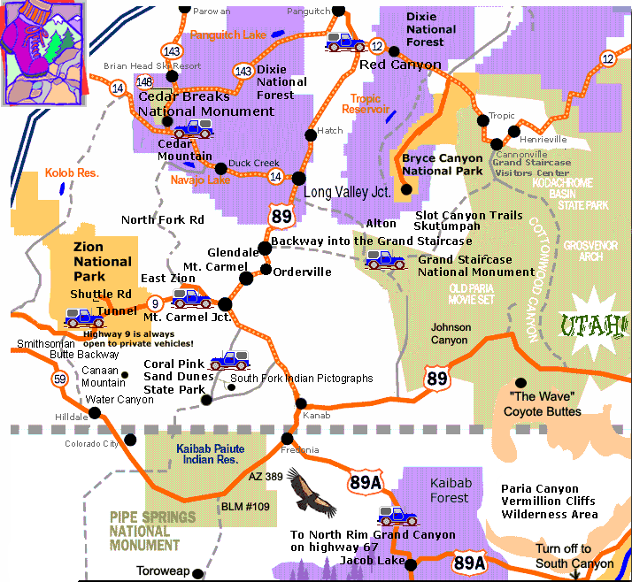
Where is Zion National Park located?
Zion National Park driving instructionsDirection to Zion National Park from the North: From Salt Lake City travel Interstate-15 south. Exit to hwy 20. Follow highway 20 to hwy 89 towards Panguitch, then past the turn-off to Bryce Canyon. Continue on hwy 89 past the turn-off to Cedar Mountain (Cedar Breaks) and continue to Mt. Carmel Jct. At the junction of hwy 9 & 89 (Mt. Carmel Jct.) turn east. [Zion National Park Lodging is here] Follow the road for 12 miles to the east entrance of Zion National Park. Directions to Zion National Park from the South: From Las Vegas travel Interstate 15 north past St. George to Exit 16. Drive through Hurricane, Utah. Follow Hwy 9 through Hurricane and to the only stop light in LaVerkin. Turn right at the stop light. Continue on Hwy 9 to the south entrance of the park. To get to the east side of Zion Park, drive through the park (highway 9 is always open!) on highway 9. Mt. Carmel Jct. is 12 miles on the east side of Zion Park.
Mileage Chart - Zion National Park
|
|
Mileage from Zion National Park (East Entrance)
|
miles
|
km
|
Mileage from intersection of highways 9 & 89. (Mt. Carmel Jct.)
|
miles
|
km
|
| Mt. Carmel Jct. (highways 9 & 89) |
12
|
19
|
Zion National Park |
12
|
19
|
| Bryce Canyon National Park |
72
|
116
|
Bryce Canyon National Park |
60
|
97
|
| Red Canyon - Dixie National Forest |
59
|
95
|
Red Canyon - Dixie National Forest |
47
|
76
|
| Cedar Breaks National Monument |
57
|
92
|
Cedar Breaks National Monument |
45
|
72
|
| Grand Staircase (entrance) |
18
|
29
|
Grand Staircase (entrance) |
6
|
9.7
|
| Coral Pink Sand Dunes |
23
|
37
|
Coral Pink Sand Dunes |
11
|
17.7
|
| Dixie National Forest (Cedar Mountain) |
34
|
55
|
Dixie Forest (Cedar Mountain) |
22
|
35
|
| |
|
|
|
|
|
|
Mileage from Zion National Park to Cities
|
Mileage from Zion National Park to the junction of highways 9 & 89 (East Zion)
|
| Cedar City, Utah |
82
|
132
|
Cedar City |
67
|
108
|
| St. George, Utah |
55
|
89
|
St. George |
67
|
108
|
| Page, Arizona |
100
|
161
|
Page, Arizona |
88
|
142
|
| Las Vegas, Nevada (airport) |
183
|
295
|
Las Vegas (airport) |
195
|
314
|
| Flagstaff, Arizona |
218
|
351
|
Flagstaff, Arizona |
206
|
332
|
| Moab, Utah |
308
|
496
|
Moab, Utah |
296
|
474
|
| Salt Lake City, Utah (airport) |
320
|
515
|
Salt Lake City (airport) |
308
|
496
|
| Albuquerque, New Mexico |
475
|
764
|
Albuquerque, New Mexico |
463
|
745
|